You are here: Home > Network List > TS - TERRAscope (Southern California Seismic Network) Stations List
> Station DGR Domenigoni Valley Reservior, California, USA > Earthquake Result Viewer
DGR Domenigoni Valley Reservior, California, USA - Earthquake Result Viewer
| Earthquake location: |
Bonin Islands, Japan Region |
| Earthquake latitude/longitude: |
29.0/138.9 |
| Earthquake time(UTC): |
1996/03/16 (076) 22:04:06 GMT |
| Earthquake Depth: |
477 km |
| Earthquake Magnitude: |
5.9 MB, 6.6 UNKNOWN, 6.1 MB |
| Earthquake Catalog/Contributor: |
WHDF/NEIC |
|
| Network: |
TS TERRAscope (Southern California Seismic Network) |
| Station: |
DGR Domenigoni Valley Reservior, California, USA |
| Lat/Lon: |
33.65 N/117.01 W |
| Elevation: |
700 m |
|
| Distance: |
84.9 deg |
| Az: |
54.33 deg |
| Baz: |
301.429 deg |
| Ray Param: |
0.043818284 |
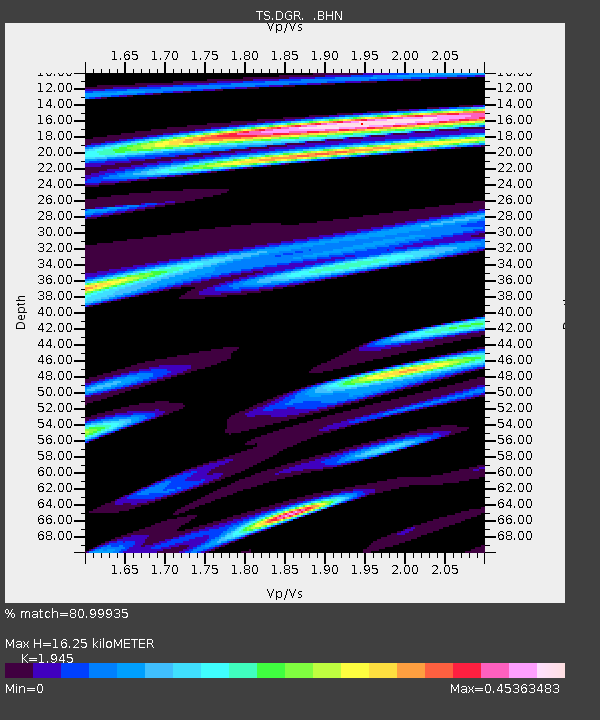
| Estimated Moho Depth: |
16.25 km |
| Estimated Crust Vp/Vs: |
1.95 |
| Assumed Crust Vp: |
6.264 km/s |
| Estimated Crust Vs: |
3.22 km/s |
| Estimated Crust Poisson's Ratio: |
0.32 |
|
| Radial Match: |
80.99935 % |
| Radial Bump: |
372 |
| Transverse Match: |
72.21433 % |
| Transverse Bump: |
400 |
| SOD ConfigId: |
6273 |
| Insert Time: |
2010-02-26 14:09:05.348 +0000 |
| GWidth: |
2.5 |
| Max Bumps: |
400 |
| Tol: |
0.001 |
|

Signal To Noise
| Channel | StoN | STA | LTA |
| TS:DGR: :BHN:19960316T22:15:18.842029Z | 1.4667472 | 2.7747288E-7 | 1.8917567E-7 |
| TS:DGR: :BHE:19960316T22:15:18.842029Z | 2.7520008 | 3.3017824E-7 | 1.1997753E-7 |
| TS:DGR: :BHZ:19960316T22:15:18.842029Z | 3.9168994 | 9.789543E-7 | 2.4993093E-7 |
| Arrivals |
| Ps | 2.5 SECOND |
| PpPs | 7.5 SECOND |
| PsPs/PpSs | 10.0 SECOND |


