You are here: Home > Network List > TA - USArray Transportable Network (new EarthScope stations) Stations List
> Station E29M Blow River, YT, CAN > Earthquake Result Viewer
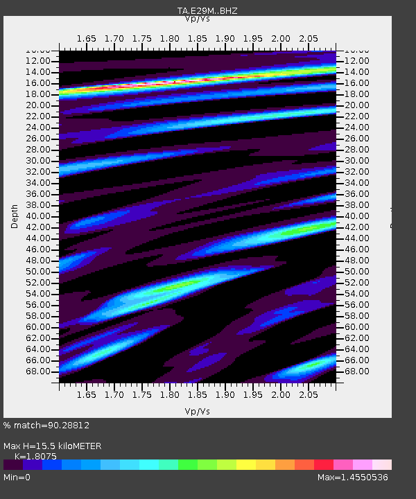
E29M Blow River, YT, CAN - Earthquake Result Viewer
| Earthquake location: |
East Of Kuril Islands |
| Earthquake latitude/longitude: |
50.5/160.0 |
| Earthquake time(UTC): |
2019/03/28 (087) 22:06:49 GMT |
| Earthquake Depth: |
9.0 km |
| Earthquake Magnitude: |
6.2 Mww |
| Earthquake Catalog/Contributor: |
NEIC PDE/us |
|
| Network: |
TA USArray Transportable Network (new EarthScope stations) |
| Station: |
E29M Blow River, YT, CAN |
| Lat/Lon: |
68.39 N/137.90 W |
| Elevation: |
324 m |
|
| Distance: |
34.4 deg |
| Az: |
35.454 deg |
| Baz: |
270.8 deg |
| Ray Param: |
0.07777597 |
| Estimated Moho Depth: |
15.5 km |
| Estimated Crust Vp/Vs: |
1.81 |
| Assumed Crust Vp: |
5.981 km/s |
| Estimated Crust Vs: |
3.309 km/s |
| Estimated Crust Poisson's Ratio: |
0.28 |
|
| Radial Match: |
90.28812 % |
| Radial Bump: |
400 |
| Transverse Match: |
74.799675 % |
| Transverse Bump: |
400 |
| SOD ConfigId: |
13570011 |
| Insert Time: |
2019-05-02 19:58:27.075 +0000 |
| GWidth: |
2.5 |
| Max Bumps: |
400 |
| Tol: |
0.001 |
|

Signal To Noise
| Channel | StoN | STA | LTA |
| TA:E29M: :BHZ:20190328T22:13:05.875006Z | 46.301044 | 3.9594556E-6 | 8.551547E-8 |
| TA:E29M: :BHN:20190328T22:13:05.875006Z | 1.7508726 | 2.6154635E-7 | 1.4938057E-7 |
| TA:E29M: :BHE:20190328T22:13:05.875006Z | 17.1694 | 1.9632776E-6 | 1.14347486E-7 |
| Arrivals |
| Ps | 2.2 SECOND |
| PpPs | 6.8 SECOND |
| PsPs/PpSs | 9.1 SECOND |


