You are here: Home > Network List > TA - USArray Transportable Network (new EarthScope stations) Stations List
> Station F26K Sheenjek River, AK, USA > Earthquake Result Viewer
F26K Sheenjek River, AK, USA - Earthquake Result Viewer
| Earthquake location: |
East Of Kuril Islands |
| Earthquake latitude/longitude: |
50.5/160.0 |
| Earthquake time(UTC): |
2019/03/28 (087) 22:06:49 GMT |
| Earthquake Depth: |
9.0 km |
| Earthquake Magnitude: |
6.2 Mww |
| Earthquake Catalog/Contributor: |
NEIC PDE/us |
|
| Network: |
TA USArray Transportable Network (new EarthScope stations) |
| Station: |
F26K Sheenjek River, AK, USA |
| Lat/Lon: |
67.69 N/144.15 W |
| Elevation: |
683 m |
|
| Distance: |
32.0 deg |
| Az: |
36.605 deg |
| Baz: |
265.973 deg |
| Ray Param: |
0.07883641 |
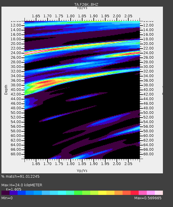
| Estimated Moho Depth: |
24.0 km |
| Estimated Crust Vp/Vs: |
1.61 |
| Assumed Crust Vp: |
6.522 km/s |
| Estimated Crust Vs: |
4.063 km/s |
| Estimated Crust Poisson's Ratio: |
0.18 |
|
| Radial Match: |
91.012245 % |
| Radial Bump: |
397 |
| Transverse Match: |
77.22391 % |
| Transverse Bump: |
400 |
| SOD ConfigId: |
13570011 |
| Insert Time: |
2019-05-02 19:58:28.102 +0000 |
| GWidth: |
2.5 |
| Max Bumps: |
400 |
| Tol: |
0.001 |
|
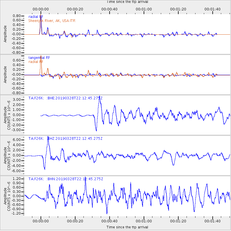
Signal To Noise
| Channel | StoN | STA | LTA |
| TA:F26K: :BHZ:20190328T22:12:45.275Z | 26.953283 | 3.2688524E-6 | 1.2127845E-7 |
| TA:F26K: :BHN:20190328T22:12:45.275Z | 2.710203 | 2.2497849E-7 | 8.301168E-8 |
| TA:F26K: :BHE:20190328T22:12:45.275Z | 22.233206 | 1.8430057E-6 | 8.289429E-8 |
| Arrivals |
| Ps | 2.4 SECOND |
| PpPs | 8.8 SECOND |
| PsPs/PpSs | 11 SECOND |


