You are here: Home > Network List > TA - USArray Transportable Network (new EarthScope stations) Stations List
> Station I27K Kandik River, AK, USA > Earthquake Result Viewer
I27K Kandik River, AK, USA - Earthquake Result Viewer
| Earthquake location: |
East Of Kuril Islands |
| Earthquake latitude/longitude: |
50.5/160.0 |
| Earthquake time(UTC): |
2019/03/28 (087) 22:06:49 GMT |
| Earthquake Depth: |
9.0 km |
| Earthquake Magnitude: |
6.2 Mww |
| Earthquake Catalog/Contributor: |
NEIC PDE/us |
|
| Network: |
TA USArray Transportable Network (new EarthScope stations) |
| Station: |
I27K Kandik River, AK, USA |
| Lat/Lon: |
65.60 N/141.62 W |
| Elevation: |
874 m |
|
| Distance: |
33.0 deg |
| Az: |
40.554 deg |
| Baz: |
271.625 deg |
| Ray Param: |
0.0784242 |
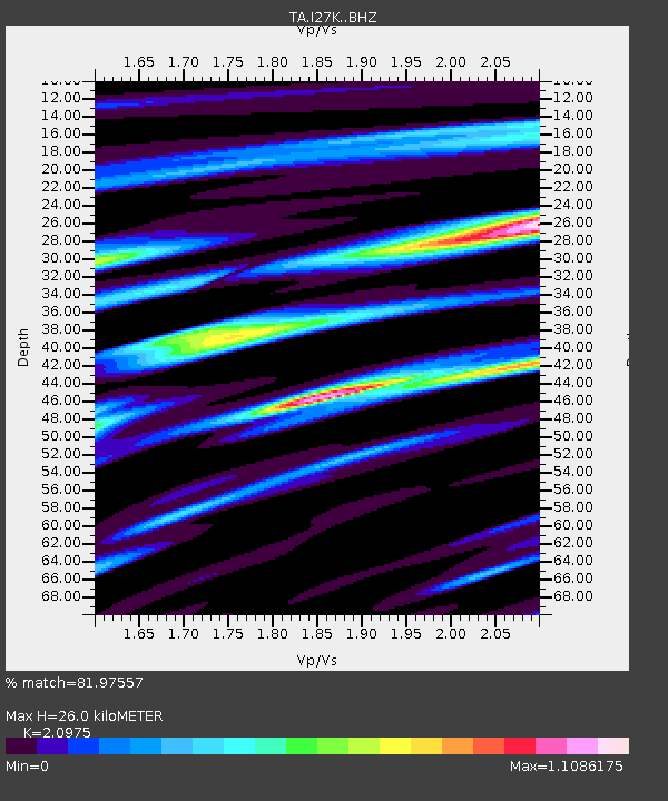
| Estimated Moho Depth: |
26.0 km |
| Estimated Crust Vp/Vs: |
2.10 |
| Assumed Crust Vp: |
6.566 km/s |
| Estimated Crust Vs: |
3.13 km/s |
| Estimated Crust Poisson's Ratio: |
0.35 |
|
| Radial Match: |
81.97557 % |
| Radial Bump: |
400 |
| Transverse Match: |
57.568714 % |
| Transverse Bump: |
400 |
| SOD ConfigId: |
13570011 |
| Insert Time: |
2019-05-02 19:58:40.465 +0000 |
| GWidth: |
2.5 |
| Max Bumps: |
400 |
| Tol: |
0.001 |
|

Signal To Noise
| Channel | StoN | STA | LTA |
| TA:I27K: :BHZ:20190328T22:12:53.699988Z | 12.323747 | 1.692264E-6 | 1.3731733E-7 |
| TA:I27K: :BHN:20190328T22:12:53.699988Z | 2.8149178 | 2.9777897E-7 | 1.0578602E-7 |
| TA:I27K: :BHE:20190328T22:12:53.699988Z | 11.197249 | 9.73061E-7 | 8.690179E-8 |
| Arrivals |
| Ps | 4.7 SECOND |
| PpPs | 11 SECOND |
| PsPs/PpSs | 16 SECOND |


