You are here: Home > Network List > TA - USArray Transportable Network (new EarthScope stations) Stations List
> Station I30M Mount Dempster, Yukon, CAN > Earthquake Result Viewer
I30M Mount Dempster, Yukon, CAN - Earthquake Result Viewer
| Earthquake location: |
East Of Kuril Islands |
| Earthquake latitude/longitude: |
50.5/160.0 |
| Earthquake time(UTC): |
2019/03/28 (087) 22:06:49 GMT |
| Earthquake Depth: |
9.0 km |
| Earthquake Magnitude: |
6.2 Mww |
| Earthquake Catalog/Contributor: |
NEIC PDE/us |
|
| Network: |
TA USArray Transportable Network (new EarthScope stations) |
| Station: |
I30M Mount Dempster, Yukon, CAN |
| Lat/Lon: |
65.22 N/136.38 W |
| Elevation: |
1399 m |
|
| Distance: |
35.2 deg |
| Az: |
40.95 deg |
| Baz: |
276.712 deg |
| Ray Param: |
0.0773571 |
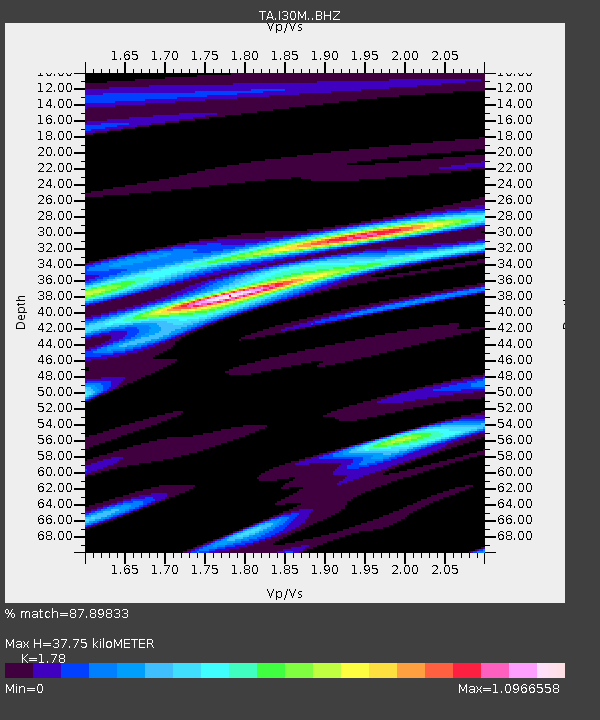
| Estimated Moho Depth: |
37.75 km |
| Estimated Crust Vp/Vs: |
1.78 |
| Assumed Crust Vp: |
6.566 km/s |
| Estimated Crust Vs: |
3.689 km/s |
| Estimated Crust Poisson's Ratio: |
0.27 |
|
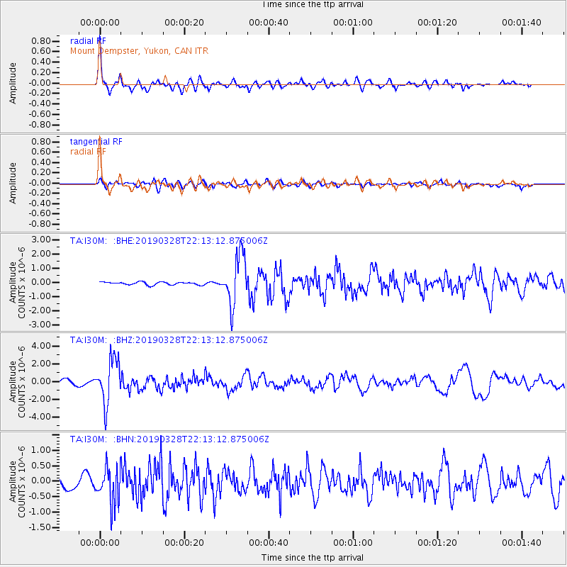
| Radial Match: |
87.89833 % |
| Radial Bump: |
400 |
| Transverse Match: |
62.288918 % |
| Transverse Bump: |
400 |
| SOD ConfigId: |
13570011 |
| Insert Time: |
2019-05-02 19:58:41.148 +0000 |
| GWidth: |
2.5 |
| Max Bumps: |
400 |
| Tol: |
0.001 |
|
Signal To Noise
| Channel | StoN | STA | LTA |
| TA:I30M: :BHZ:20190328T22:13:12.875006Z | 10.249051 | 2.5428535E-6 | 2.4810623E-7 |
| TA:I30M: :BHN:20190328T22:13:12.875006Z | 2.6605945 | 5.8466463E-7 | 2.1974964E-7 |
| TA:I30M: :BHE:20190328T22:13:12.875006Z | 17.449501 | 1.7900246E-6 | 1.0258314E-7 |
| Arrivals |
| Ps | 4.9 SECOND |
| PpPs | 15 SECOND |
| PsPs/PpSs | 20 SECOND |


