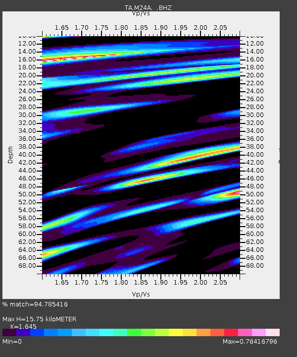
M24A Cheyenne, WY, USA - Earthquake Result Viewer
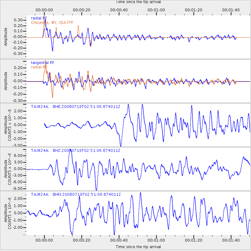
Earthquake location: Off East Coast Of Honshu, Japan
Earthquake latitude/longitude: 37.6/142.2
Earthquake time(UTC): 2008/07/19 (201) 02:39:28 GMT
Earthquake Depth: 22 km
Earthquake Magnitude: 6.2 MB, 7.0 MS, 7.0 MW, 6.9 MW
Earthquake Catalog/Contributor: WHDF/NEIC
Network: TA USArray Transportable Network (new EarthScope stations)
Station: M24A Cheyenne, WY, USA
Lat/Lon: 41.47 N/104.82 W
Elevation: 1816 m
Distance: 80.4 deg
Az: 44.579 deg
Baz: 312.075 deg
Ray Param: 0.048303895
Estimated Moho Depth: 15.75 km
Estimated Crust Vp/Vs: 1.64
Assumed Crust Vp: 6.306 km/s
Estimated Crust Vs: 3.833 km/s
Estimated Crust Poisson's Ratio: 0.21
Radial Match: 94.785416 %
Radial Bump: 400
Transverse Match: 86.62409 %
Transverse Bump: 400
SOD ConfigId: 2504
Insert Time: 2010-03-06 21:03:14.531 +0000
GWidth: 2.5
Max Bumps: 400
Tol: 0.001

Signal To Noise

ChannelStoNSTALTA
TA:M24A: :BHZ:20080719T02:51:06.874011Z10.1613731.0350772E-61.01863904E-7
TA:M24A: :BHN:20080719T02:51:06.874011Z2.18455772.8791953E-71.3179763E-7
TA:M24A: :BHE:20080719T02:51:06.874011Z1.05791962.4304074E-72.2973458E-7
Arrivals
Ps1.7 SECOND
PpPs6.4 SECOND
PsPs/PpSs8.1 SECOND