You are here: Home > Network List > TA - USArray Transportable Network (new EarthScope stations) Stations List
> Station M24A Cheyenne, WY, USA > Earthquake Result Viewer
M24A Cheyenne, WY, USA - Earthquake Result Viewer
| Earthquake location: |
Near S. Coast Of Honshu, Japan |
| Earthquake latitude/longitude: |
33.2/137.9 |
| Earthquake time(UTC): |
2009/08/09 (221) 10:55:55 GMT |
| Earthquake Depth: |
297 km |
| Earthquake Magnitude: |
6.5 MB, 7.1 MW, 7.1 MW |
| Earthquake Catalog/Contributor: |
WHDF/NEIC |
|
| Network: |
TA USArray Transportable Network (new EarthScope stations) |
| Station: |
M24A Cheyenne, WY, USA |
| Lat/Lon: |
41.47 N/104.82 W |
| Elevation: |
1816 m |
|
| Distance: |
85.9 deg |
| Az: |
42.059 deg |
| Baz: |
311.613 deg |
| Ray Param: |
0.043664213 |
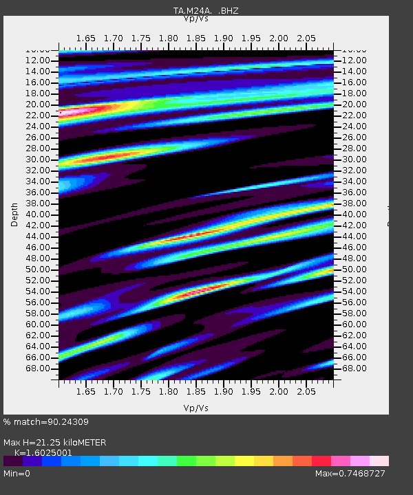
| Estimated Moho Depth: |
21.25 km |
| Estimated Crust Vp/Vs: |
1.60 |
| Assumed Crust Vp: |
6.306 km/s |
| Estimated Crust Vs: |
3.935 km/s |
| Estimated Crust Poisson's Ratio: |
0.18 |
|
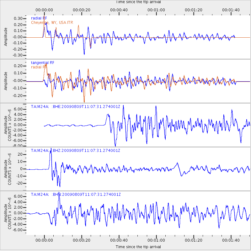
| Radial Match: |
90.24309 % |
| Radial Bump: |
400 |
| Transverse Match: |
81.44504 % |
| Transverse Bump: |
400 |
| SOD ConfigId: |
2622 |
| Insert Time: |
2010-03-06 21:03:31.652 +0000 |
| GWidth: |
2.5 |
| Max Bumps: |
400 |
| Tol: |
0.001 |
|
Signal To Noise
| Channel | StoN | STA | LTA |
| TA:M24A: :BHZ:20090809T11:07:31.274001Z | 106.49251 | 1.1157537E-5 | 1.0477298E-7 |
| TA:M24A: :BHN:20090809T11:07:31.274001Z | 7.5511036 | 1.6289304E-6 | 2.1572083E-7 |
| TA:M24A: :BHE:20090809T11:07:31.274001Z | 12.21189 | 2.0454838E-6 | 1.6749937E-7 |
| Arrivals |
| Ps | 2.1 SECOND |
| PpPs | 8.6 SECOND |
| PsPs/PpSs | 11 SECOND |


