You are here: Home > Network List > TM - Thai Seismic Monitoring Network Stations List
> Station MHIT MHIT Phase1 > Earthquake Result Viewer
MHIT MHIT Phase1 - Earthquake Result Viewer
| Earthquake location: |
East Of Kuril Islands |
| Earthquake latitude/longitude: |
50.5/160.0 |
| Earthquake time(UTC): |
2019/03/28 (087) 22:06:49 GMT |
| Earthquake Depth: |
9.0 km |
| Earthquake Magnitude: |
6.2 Mww |
| Earthquake Catalog/Contributor: |
NEIC PDE/us |
|
| Network: |
TM Thai Seismic Monitoring Network |
| Station: |
MHIT MHIT Phase1 |
| Lat/Lon: |
19.31 N/97.96 E |
| Elevation: |
270 m |
|
| Distance: |
57.6 deg |
| Az: |
261.056 deg |
| Baz: |
41.91 deg |
| Ray Param: |
0.063403785 |
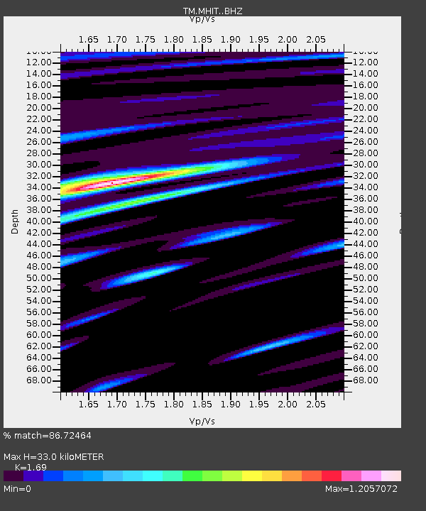
| Estimated Moho Depth: |
33.0 km |
| Estimated Crust Vp/Vs: |
1.69 |
| Assumed Crust Vp: |
6.316 km/s |
| Estimated Crust Vs: |
3.737 km/s |
| Estimated Crust Poisson's Ratio: |
0.23 |
|
| Radial Match: |
86.72464 % |
| Radial Bump: |
400 |
| Transverse Match: |
90.38018 % |
| Transverse Bump: |
400 |
| SOD ConfigId: |
13570011 |
| Insert Time: |
2019-05-02 19:59:21.138 +0000 |
| GWidth: |
2.5 |
| Max Bumps: |
400 |
| Tol: |
0.001 |
|

Signal To Noise
| Channel | StoN | STA | LTA |
| TM:MHIT: :BHZ:20190328T22:16:08.300024Z | 21.683357 | 1.354529E-6 | 6.24686E-8 |
| TM:MHIT: :BHN:20190328T22:16:08.300024Z | 6.716636 | 1.2658039E-6 | 1.8845802E-7 |
| TM:MHIT: :BHE:20190328T22:16:08.300024Z | 3.3347178 | 2.4981688E-7 | 7.491395E-8 |
| Arrivals |
| Ps | 3.8 SECOND |
| PpPs | 13 SECOND |
| PsPs/PpSs | 17 SECOND |


