You are here: Home > Network List > TA - USArray Transportable Network (new EarthScope stations) Stations List
> Station M24A Cheyenne, WY, USA > Earthquake Result Viewer
M24A Cheyenne, WY, USA - Earthquake Result Viewer
| Earthquake location: |
Hokkaido, Japan Region |
| Earthquake latitude/longitude: |
41.8/143.4 |
| Earthquake time(UTC): |
2009/06/05 (156) 03:30:33 GMT |
| Earthquake Depth: |
29 km |
| Earthquake Magnitude: |
6.0 MB, 6.3 MS, 6.4 MW, 6.4 MW |
| Earthquake Catalog/Contributor: |
WHDF/NEIC |
|
| Network: |
TA USArray Transportable Network (new EarthScope stations) |
| Station: |
M24A Cheyenne, WY, USA |
| Lat/Lon: |
41.47 N/104.82 W |
| Elevation: |
1816 m |
|
| Distance: |
76.7 deg |
| Az: |
45.841 deg |
| Baz: |
314.481 deg |
| Ray Param: |
0.050790556 |
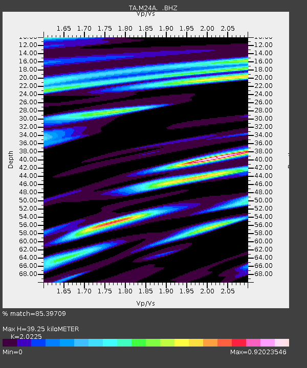
| Estimated Moho Depth: |
39.25 km |
| Estimated Crust Vp/Vs: |
2.02 |
| Assumed Crust Vp: |
6.306 km/s |
| Estimated Crust Vs: |
3.118 km/s |
| Estimated Crust Poisson's Ratio: |
0.34 |
|
| Radial Match: |
85.39709 % |
| Radial Bump: |
378 |
| Transverse Match: |
80.69386 % |
| Transverse Bump: |
400 |
| SOD ConfigId: |
2648 |
| Insert Time: |
2010-03-06 21:03:41.013 +0000 |
| GWidth: |
2.5 |
| Max Bumps: |
400 |
| Tol: |
0.001 |
|
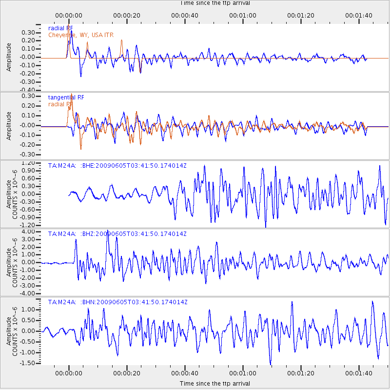
Signal To Noise
| Channel | StoN | STA | LTA |
| TA:M24A: :BHZ:20090605T03:41:50.174014Z | 15.291981 | 1.0906755E-6 | 7.1323356E-8 |
| TA:M24A: :BHN:20090605T03:41:50.174014Z | 2.341391 | 2.6890598E-7 | 1.1484881E-7 |
| TA:M24A: :BHE:20090605T03:41:50.174014Z | 1.4863416 | 2.1647551E-7 | 1.4564318E-7 |
| Arrivals |
| Ps | 6.5 SECOND |
| PpPs | 18 SECOND |
| PsPs/PpSs | 25 SECOND |


