You are here: Home > Network List > TA - USArray Transportable Network (new EarthScope stations) Stations List
> Station M24A Cheyenne, WY, USA > Earthquake Result Viewer
M24A Cheyenne, WY, USA - Earthquake Result Viewer
| Earthquake location: |
Northern Mid-Atlantic Ridge |
| Earthquake latitude/longitude: |
23.9/-46.1 |
| Earthquake time(UTC): |
2009/06/06 (157) 20:33:28 GMT |
| Earthquake Depth: |
14 km |
| Earthquake Magnitude: |
6.0 MB, 5.7 MS, 6.0 MW, 6.0 MW |
| Earthquake Catalog/Contributor: |
WHDF/NEIC |
|
| Network: |
TA USArray Transportable Network (new EarthScope stations) |
| Station: |
M24A Cheyenne, WY, USA |
| Lat/Lon: |
41.47 N/104.82 W |
| Elevation: |
1816 m |
|
| Distance: |
51.5 deg |
| Az: |
304.834 deg |
| Baz: |
90.824 deg |
| Ray Param: |
0.067371204 |
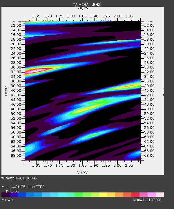
| Estimated Moho Depth: |
31.25 km |
| Estimated Crust Vp/Vs: |
1.65 |
| Assumed Crust Vp: |
6.306 km/s |
| Estimated Crust Vs: |
3.822 km/s |
| Estimated Crust Poisson's Ratio: |
0.21 |
|
| Radial Match: |
81.36042 % |
| Radial Bump: |
400 |
| Transverse Match: |
71.82577 % |
| Transverse Bump: |
400 |
| SOD ConfigId: |
2648 |
| Insert Time: |
2010-03-06 21:03:42.440 +0000 |
| GWidth: |
2.5 |
| Max Bumps: |
400 |
| Tol: |
0.001 |
|

Signal To Noise
| Channel | StoN | STA | LTA |
| TA:M24A: :BHZ:20090606T20:42:02.798994Z | 4.98064 | 7.6233187E-7 | 1.5305902E-7 |
| TA:M24A: :BHN:20090606T20:42:02.798994Z | 0.8449056 | 1.7693694E-7 | 2.0941621E-7 |
| TA:M24A: :BHE:20090606T20:42:02.798994Z | 1.4300163 | 2.0544333E-7 | 1.4366503E-7 |
| Arrivals |
| Ps | 3.4 SECOND |
| PpPs | 12 SECOND |
| PsPs/PpSs | 16 SECOND |


