You are here: Home > Network List > TS - TERRAscope (Southern California Seismic Network) Stations List
> Station DGR Domenigoni Valley Reservior, California, USA > Earthquake Result Viewer
DGR Domenigoni Valley Reservior, California, USA - Earthquake Result Viewer
| Earthquake location: |
Off Coast Of Northern Peru |
| Earthquake latitude/longitude: |
-9.6/-79.6 |
| Earthquake time(UTC): |
1996/02/21 (052) 12:51:04 GMT |
| Earthquake Depth: |
33 km |
| Earthquake Magnitude: |
5.8 MB, 6.6 MS, 7.5 UNKNOWN, 7.3 MW |
| Earthquake Catalog/Contributor: |
WHDF/NEIC |
|
| Network: |
TS TERRAscope (Southern California Seismic Network) |
| Station: |
DGR Domenigoni Valley Reservior, California, USA |
| Lat/Lon: |
33.65 N/117.01 W |
| Elevation: |
700 m |
|
| Distance: |
55.8 deg |
| Az: |
322.203 deg |
| Baz: |
133.571 deg |
| Ray Param: |
0.06447357 |
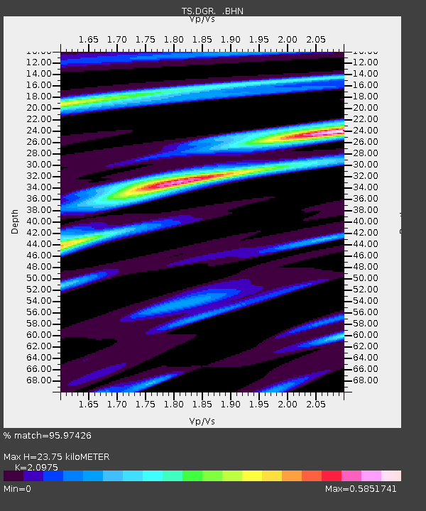
| Estimated Moho Depth: |
23.75 km |
| Estimated Crust Vp/Vs: |
2.10 |
| Assumed Crust Vp: |
6.264 km/s |
| Estimated Crust Vs: |
2.986 km/s |
| Estimated Crust Poisson's Ratio: |
0.35 |
|
| Radial Match: |
95.97426 % |
| Radial Bump: |
218 |
| Transverse Match: |
82.506676 % |
| Transverse Bump: |
399 |
| SOD ConfigId: |
6273 |
| Insert Time: |
2010-02-26 14:09:06.818 +0000 |
| GWidth: |
2.5 |
| Max Bumps: |
400 |
| Tol: |
0.001 |
|

Signal To Noise
| Channel | StoN | STA | LTA |
| TS:DGR: :BHN:19960221T13:00:07.794019Z | 1.3657862 | 3.3030136E-7 | 2.4183973E-7 |
| TS:DGR: :BHE:19960221T13:00:07.794019Z | 1.8142829 | 5.70784E-7 | 3.1460584E-7 |
| TS:DGR: :BHZ:19960221T13:00:07.794019Z | 2.0584314 | 7.446195E-7 | 3.6174123E-7 |
| Arrivals |
| Ps | 4.3 SECOND |
| PpPs | 11 SECOND |
| PsPs/PpSs | 16 SECOND |


