You are here: Home > Network List > TA - USArray Transportable Network (new EarthScope stations) Stations List
> Station M24A Cheyenne, WY, USA > Earthquake Result Viewer
M24A Cheyenne, WY, USA - Earthquake Result Viewer
| Earthquake location: |
Kuril Islands |
| Earthquake latitude/longitude: |
46.0/151.4 |
| Earthquake time(UTC): |
2009/04/18 (108) 19:17:58 GMT |
| Earthquake Depth: |
35 km |
| Earthquake Magnitude: |
6.3 MB, 6.3 MS, 6.6 MW, 6.4 MW |
| Earthquake Catalog/Contributor: |
WHDF/NEIC |
|
| Network: |
TA USArray Transportable Network (new EarthScope stations) |
| Station: |
M24A Cheyenne, WY, USA |
| Lat/Lon: |
41.47 N/104.82 W |
| Elevation: |
1816 m |
|
| Distance: |
69.6 deg |
| Az: |
51.158 deg |
| Baz: |
313.761 deg |
| Ray Param: |
0.055487745 |
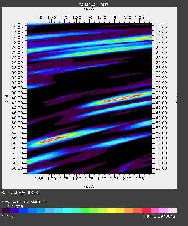
| Estimated Moho Depth: |
40.0 km |
| Estimated Crust Vp/Vs: |
1.98 |
| Assumed Crust Vp: |
6.306 km/s |
| Estimated Crust Vs: |
3.193 km/s |
| Estimated Crust Poisson's Ratio: |
0.33 |
|
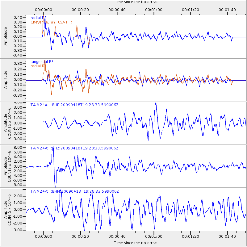
| Radial Match: |
90.98131 % |
| Radial Bump: |
400 |
| Transverse Match: |
81.88274 % |
| Transverse Bump: |
388 |
| SOD ConfigId: |
2658 |
| Insert Time: |
2010-03-06 21:03:46.607 +0000 |
| GWidth: |
2.5 |
| Max Bumps: |
400 |
| Tol: |
0.001 |
|
Signal To Noise
| Channel | StoN | STA | LTA |
| TA:M24A: :BHZ:20090418T19:28:33.599006Z | 14.976634 | 2.0690234E-6 | 1.381501E-7 |
| TA:M24A: :BHN:20090418T19:28:33.599006Z | 1.4352534 | 5.5796033E-7 | 3.887539E-7 |
| TA:M24A: :BHE:20090418T19:28:33.599006Z | 0.87140113 | 4.948352E-7 | 5.6786155E-7 |
| Arrivals |
| Ps | 6.4 SECOND |
| PpPs | 18 SECOND |
| PsPs/PpSs | 25 SECOND |


