You are here: Home > Network List > TA - USArray Transportable Network (new EarthScope stations) Stations List
> Station M24A Cheyenne, WY, USA > Earthquake Result Viewer
M24A Cheyenne, WY, USA - Earthquake Result Viewer
| Earthquake location: |
Off Coast Of Ecuador |
| Earthquake latitude/longitude: |
1.4/-85.2 |
| Earthquake time(UTC): |
2009/05/10 (130) 01:16:06 GMT |
| Earthquake Depth: |
6.0 km |
| Earthquake Magnitude: |
5.5 MB, 5.7 MS, 6.1 MW, 6.1 MW |
| Earthquake Catalog/Contributor: |
WHDF/NEIC |
|
| Network: |
TA USArray Transportable Network (new EarthScope stations) |
| Station: |
M24A Cheyenne, WY, USA |
| Lat/Lon: |
41.47 N/104.82 W |
| Elevation: |
1816 m |
|
| Distance: |
43.7 deg |
| Az: |
338.52 deg |
| Baz: |
150.85 deg |
| Ray Param: |
0.072420284 |
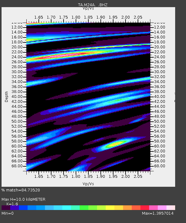
| Estimated Moho Depth: |
10.0 km |
| Estimated Crust Vp/Vs: |
1.60 |
| Assumed Crust Vp: |
6.306 km/s |
| Estimated Crust Vs: |
3.941 km/s |
| Estimated Crust Poisson's Ratio: |
0.18 |
|
| Radial Match: |
84.73528 % |
| Radial Bump: |
357 |
| Transverse Match: |
52.407024 % |
| Transverse Bump: |
375 |
| SOD ConfigId: |
2760 |
| Insert Time: |
2010-03-06 21:04:02.119 +0000 |
| GWidth: |
2.5 |
| Max Bumps: |
400 |
| Tol: |
0.001 |
|
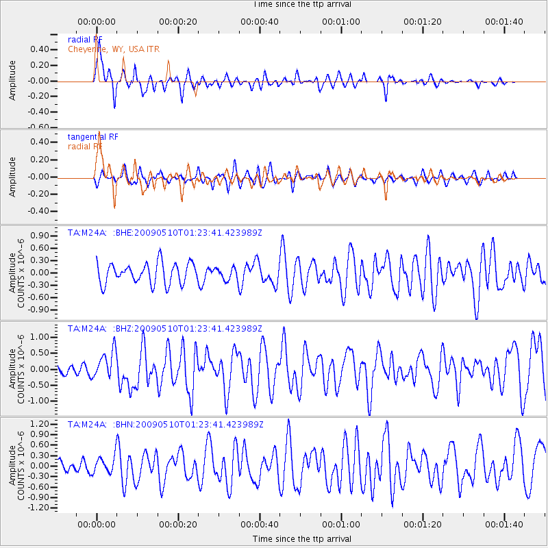
Signal To Noise
| Channel | StoN | STA | LTA |
| TA:M24A: :BHZ:20090510T01:23:41.423989Z | 2.5126436 | 4.5535245E-7 | 1.8122445E-7 |
| TA:M24A: :BHN:20090510T01:23:41.423989Z | 1.485542 | 2.498664E-7 | 1.6819881E-7 |
| TA:M24A: :BHE:20090510T01:23:41.423989Z | 0.6218379 | 1.5461181E-7 | 2.4863684E-7 |
| Arrivals |
| Ps | 1.0 SECOND |
| PpPs | 3.8 SECOND |
| PsPs/PpSs | 4.9 SECOND |


