You are here: Home > Network List > TA - USArray Transportable Network (new EarthScope stations) Stations List
> Station M24A Cheyenne, WY, USA > Earthquake Result Viewer
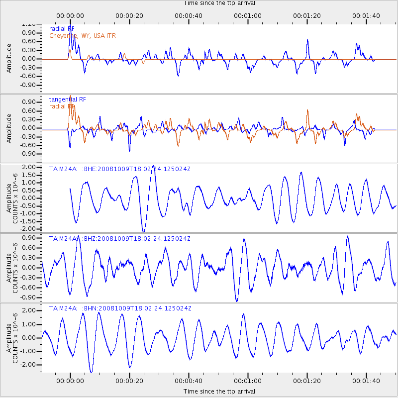
M24A Cheyenne, WY, USA - Earthquake Result Viewer
*The percent match for this event was below the threshold and hence no stack was calculated.
| Earthquake location: |
Tonga Islands |
| Earthquake latitude/longitude: |
-21.0/-174.4 |
| Earthquake time(UTC): |
2008/10/09 (283) 17:49:58 GMT |
| Earthquake Depth: |
10 km |
| Earthquake Magnitude: |
5.8 MB, 5.6 MS, 5.9 MW, 5.9 MW |
| Earthquake Catalog/Contributor: |
WHDF/NEIC |
|
| Network: |
TA USArray Transportable Network (new EarthScope stations) |
| Station: |
M24A Cheyenne, WY, USA |
| Lat/Lon: |
41.47 N/104.82 W |
| Elevation: |
1816 m |
|
| Distance: |
89.5 deg |
| Az: |
44.782 deg |
| Baz: |
241.118 deg |
| Ray Param: |
$rayparam |
*The percent match for this event was below the threshold and hence was not used in the summary stack. |
|
| Radial Match: |
46.036015 % |
| Radial Bump: |
400 |
| Transverse Match: |
58.29106 % |
| Transverse Bump: |
329 |
| SOD ConfigId: |
2556 |
| Insert Time: |
2010-03-06 21:04:07.684 +0000 |
| GWidth: |
2.5 |
| Max Bumps: |
400 |
| Tol: |
0.001 |
|
Signal To Noise
| Channel | StoN | STA | LTA |
| TA:M24A: :BHZ:20081009T18:02:24.125024Z | 1.6454679 | 5.855285E-7 | 3.5584316E-7 |
| TA:M24A: :BHN:20081009T18:02:24.125024Z | 1.6556245 | 1.085662E-6 | 6.557417E-7 |
| TA:M24A: :BHE:20081009T18:02:24.125024Z | 0.9067366 | 7.419241E-7 | 8.182355E-7 |
| Arrivals |
| Ps | |
| PpPs | |
| PsPs/PpSs | |


