You are here: Home > Network List > XU16 - USGS NEHRP Proposal 2016-2018 - Greeley, CO Stations List
> Station GRCO Chill station, CO, USA > Earthquake Result Viewer
GRCO Chill station, CO, USA - Earthquake Result Viewer
| Earthquake location: |
East Of Kuril Islands |
| Earthquake latitude/longitude: |
50.5/160.0 |
| Earthquake time(UTC): |
2019/03/28 (087) 22:06:49 GMT |
| Earthquake Depth: |
9.0 km |
| Earthquake Magnitude: |
6.2 Mww |
| Earthquake Catalog/Contributor: |
NEIC PDE/us |
|
| Network: |
XU USGS NEHRP Proposal 2016-2018 - Greeley, CO |
| Station: |
GRCO Chill station, CO, USA |
| Lat/Lon: |
40.45 N/104.64 W |
| Elevation: |
1427 m |
|
| Distance: |
63.2 deg |
| Az: |
58.372 deg |
| Baz: |
314.562 deg |
| Ray Param: |
0.059756737 |
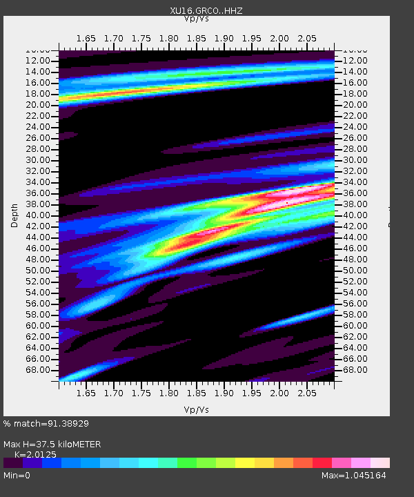
| Estimated Moho Depth: |
37.5 km |
| Estimated Crust Vp/Vs: |
2.01 |
| Assumed Crust Vp: |
6.306 km/s |
| Estimated Crust Vs: |
3.133 km/s |
| Estimated Crust Poisson's Ratio: |
0.34 |
|
| Radial Match: |
91.38929 % |
| Radial Bump: |
400 |
| Transverse Match: |
66.7204 % |
| Transverse Bump: |
400 |
| SOD ConfigId: |
13570011 |
| Insert Time: |
2019-05-02 20:00:52.799 +0000 |
| GWidth: |
2.5 |
| Max Bumps: |
400 |
| Tol: |
0.001 |
|

Signal To Noise
| Channel | StoN | STA | LTA |
| XU:GRCO: :HHZ:20190328T22:16:46.433997Z | 28.724218 | 5.9089707E-6 | 2.0571389E-7 |
| XU:GRCO: :HH1:20190328T22:16:46.433997Z | 2.4354768 | 1.1444109E-6 | 4.6989192E-7 |
| XU:GRCO: :HH2:20190328T22:16:46.433997Z | 2.5155306 | 1.2938508E-6 | 5.143451E-7 |
| Arrivals |
| Ps | 6.2 SECOND |
| PpPs | 17 SECOND |
| PsPs/PpSs | 24 SECOND |


