You are here: Home > Network List > YO16 - Yukon Observatory Stations List
> Station KOTA YGS, Kotaneelee Airstrip, YK > Earthquake Result Viewer
KOTA YGS, Kotaneelee Airstrip, YK - Earthquake Result Viewer
| Earthquake location: |
East Of Kuril Islands |
| Earthquake latitude/longitude: |
50.5/160.0 |
| Earthquake time(UTC): |
2019/03/28 (087) 22:06:49 GMT |
| Earthquake Depth: |
9.0 km |
| Earthquake Magnitude: |
6.2 Mww |
| Earthquake Catalog/Contributor: |
NEIC PDE/us |
|
| Network: |
YO Yukon Observatory |
| Station: |
KOTA YGS, Kotaneelee Airstrip, YK |
| Lat/Lon: |
60.13 N/124.05 W |
| Elevation: |
386 m |
|
| Distance: |
42.0 deg |
| Az: |
46.582 deg |
| Baz: |
292.078 deg |
| Ray Param: |
0.07346317 |
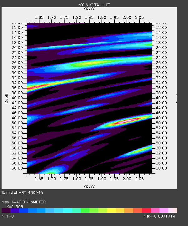
| Estimated Moho Depth: |
49.0 km |
| Estimated Crust Vp/Vs: |
2.00 |
| Assumed Crust Vp: |
6.419 km/s |
| Estimated Crust Vs: |
3.218 km/s |
| Estimated Crust Poisson's Ratio: |
0.33 |
|
| Radial Match: |
82.460945 % |
| Radial Bump: |
400 |
| Transverse Match: |
72.6366 % |
| Transverse Bump: |
400 |
| SOD ConfigId: |
13570011 |
| Insert Time: |
2019-05-02 20:00:56.557 +0000 |
| GWidth: |
2.5 |
| Max Bumps: |
400 |
| Tol: |
0.001 |
|

Signal To Noise
| Channel | StoN | STA | LTA |
| YO:KOTA: :HHZ:20190328T22:14:09.63999Z | 10.218324 | 4.2403067E-6 | 4.1497088E-7 |
| YO:KOTA: :HHN:20190328T22:14:09.63999Z | 2.263544 | 6.249008E-7 | 2.7607183E-7 |
| YO:KOTA: :HHE:20190328T22:14:09.63999Z | 6.714538 | 1.9622391E-6 | 2.922374E-7 |
| Arrivals |
| Ps | 8.1 SECOND |
| PpPs | 22 SECOND |
| PsPs/PpSs | 30 SECOND |


