You are here: Home > Network List > TA - USArray Transportable Network (new EarthScope stations) Stations List
> Station M24A Cheyenne, WY, USA > Earthquake Result Viewer
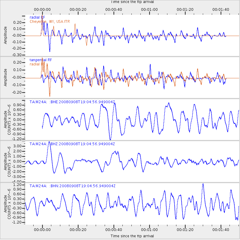
M24A Cheyenne, WY, USA - Earthquake Result Viewer
*The percent match for this event was below the threshold and hence no stack was calculated.
| Earthquake location: |
Vanuatu Islands |
| Earthquake latitude/longitude: |
-13.5/167.0 |
| Earthquake time(UTC): |
2008/09/08 (252) 18:52:06 GMT |
| Earthquake Depth: |
110 km |
| Earthquake Magnitude: |
6.4 MB, 6.9 MW, 6.9 MW |
| Earthquake Catalog/Contributor: |
WHDF/NEIC |
|
| Network: |
TA USArray Transportable Network (new EarthScope stations) |
| Station: |
M24A Cheyenne, WY, USA |
| Lat/Lon: |
41.47 N/104.82 W |
| Elevation: |
1816 m |
|
| Distance: |
97.5 deg |
| Az: |
49.254 deg |
| Baz: |
258.692 deg |
| Ray Param: |
$rayparam |
*The percent match for this event was below the threshold and hence was not used in the summary stack. |
|
| Radial Match: |
76.691734 % |
| Radial Bump: |
400 |
| Transverse Match: |
63.075386 % |
| Transverse Bump: |
400 |
| SOD ConfigId: |
2560 |
| Insert Time: |
2010-03-06 21:04:10.994 +0000 |
| GWidth: |
2.5 |
| Max Bumps: |
400 |
| Tol: |
0.001 |
|
Signal To Noise
| Channel | StoN | STA | LTA |
| TA:M24A: :BHZ:20080908T19:04:56.949004Z | 8.932049 | 2.0267146E-6 | 2.2690368E-7 |
| TA:M24A: :BHN:20080908T19:04:56.949004Z | 0.64610463 | 1.8787364E-7 | 2.9077898E-7 |
| TA:M24A: :BHE:20080908T19:04:56.949004Z | 2.526426 | 6.020905E-7 | 2.383171E-7 |
| Arrivals |
| Ps | |
| PpPs | |
| PsPs/PpSs | |


