You are here: Home > Network List > TA - USArray Transportable Network (new EarthScope stations) Stations List
> Station M24A Cheyenne, WY, USA > Earthquake Result Viewer
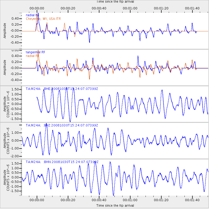
M24A Cheyenne, WY, USA - Earthquake Result Viewer
*The percent match for this event was below the threshold and hence no stack was calculated.
| Earthquake location: |
Central East Pacific Rise |
| Earthquake latitude/longitude: |
-9.0/-108.2 |
| Earthquake time(UTC): |
2008/10/30 (304) 15:15:41 GMT |
| Earthquake Depth: |
10 km |
| Earthquake Magnitude: |
5.5 MB, 5.8 MS, 6.0 MW, 6.0 MW |
| Earthquake Catalog/Contributor: |
WHDF/NEIC |
|
| Network: |
TA USArray Transportable Network (new EarthScope stations) |
| Station: |
M24A Cheyenne, WY, USA |
| Lat/Lon: |
41.47 N/104.82 W |
| Elevation: |
1816 m |
|
| Distance: |
50.3 deg |
| Az: |
3.34 deg |
| Baz: |
184.392 deg |
| Ray Param: |
$rayparam |
*The percent match for this event was below the threshold and hence was not used in the summary stack. |
|
| Radial Match: |
57.61296 % |
| Radial Bump: |
307 |
| Transverse Match: |
49.919567 % |
| Transverse Bump: |
327 |
| SOD ConfigId: |
2560 |
| Insert Time: |
2010-03-06 21:04:12.602 +0000 |
| GWidth: |
2.5 |
| Max Bumps: |
400 |
| Tol: |
0.001 |
|
Signal To Noise
| Channel | StoN | STA | LTA |
| TA:M24A: :BHZ:20081030T15:24:07.07399Z | 2.226731 | 9.35777E-7 | 4.2024698E-7 |
| TA:M24A: :BHN:20081030T15:24:07.07399Z | 0.35498816 | 2.5687976E-7 | 7.236291E-7 |
| TA:M24A: :BHE:20081030T15:24:07.07399Z | 0.5457509 | 5.343593E-7 | 9.791266E-7 |
| Arrivals |
| Ps | |
| PpPs | |
| PsPs/PpSs | |


