You are here: Home > Network List > PF - Volcanologic Network of Piton de Fournaise-OVPF Stations List
> Station HIM cratere Himiltrude > Earthquake Result Viewer
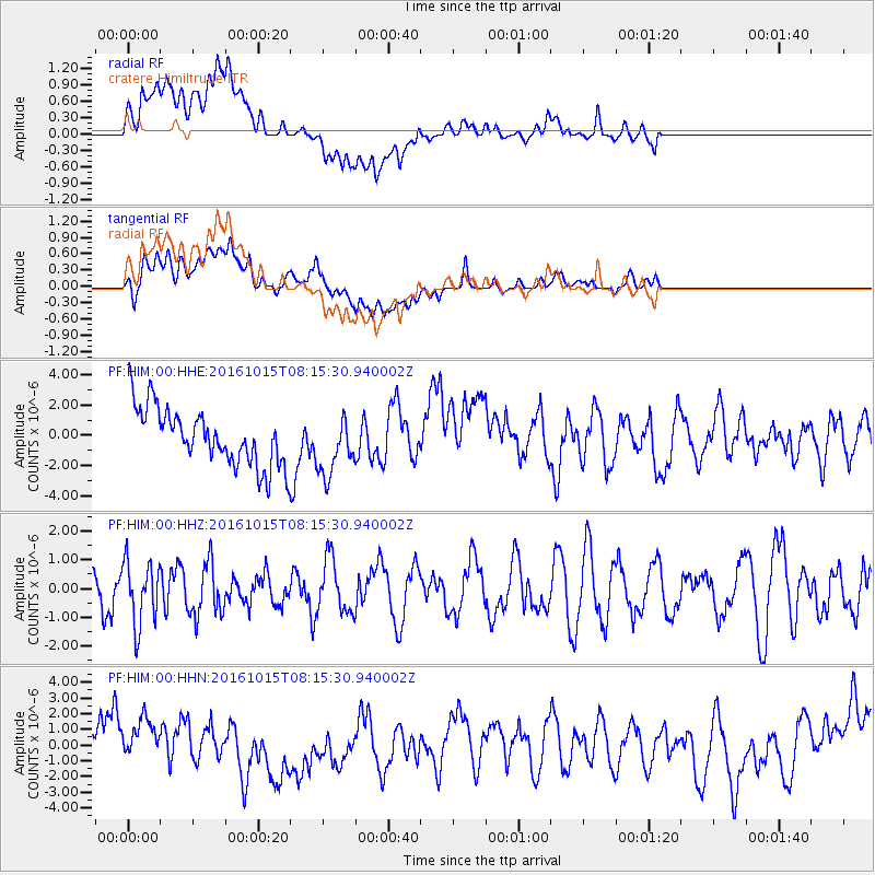
HIM cratere Himiltrude - Earthquake Result Viewer
*The percent match for this event was below the threshold and hence no stack was calculated.
| Earthquake location: |
New Britain Region, P.N.G. |
| Earthquake latitude/longitude: |
-4.3/150.4 |
| Earthquake time(UTC): |
2016/10/15 (289) 08:03:39 GMT |
| Earthquake Depth: |
451 km |
| Earthquake Magnitude: |
6.0 MB |
| Earthquake Catalog/Contributor: |
NEIC PDE/NEIC ALERT |
|
| Network: |
PF Volcanologic Network of Piton de Fournaise-OVPF |
| Station: |
HIM cratere Himiltrude |
| Lat/Lon: |
21.21 S/55.72 E |
| Elevation: |
1958 m |
|
| Distance: |
92.8 deg |
| Az: |
248.605 deg |
| Baz: |
95.651 deg |
| Ray Param: |
$rayparam |
*The percent match for this event was below the threshold and hence was not used in the summary stack. |
|
| Radial Match: |
52.970894 % |
| Radial Bump: |
400 |
| Transverse Match: |
51.939808 % |
| Transverse Bump: |
400 |
| SOD ConfigId: |
1634031 |
| Insert Time: |
2016-10-29 08:08:28.220 +0000 |
| GWidth: |
2.5 |
| Max Bumps: |
400 |
| Tol: |
0.001 |
|
Signal To Noise
| Channel | StoN | STA | LTA |
| PF:HIM:00:HHZ:20161015T08:15:30.940002Z | 1.1630968 | 1.0944079E-6 | 9.4094315E-7 |
| PF:HIM:00:HHN:20161015T08:15:30.940002Z | 0.8204258 | 1.4918159E-6 | 1.8183433E-6 |
| PF:HIM:00:HHE:20161015T08:15:30.940002Z | 1.0154417 | 1.9465865E-6 | 1.9169852E-6 |
| Arrivals |
| Ps | |
| PpPs | |
| PsPs/PpSs | |


