You are here: Home > Network List > TA - USArray Transportable Network (new EarthScope stations) Stations List
> Station M24A Cheyenne, WY, USA > Earthquake Result Viewer
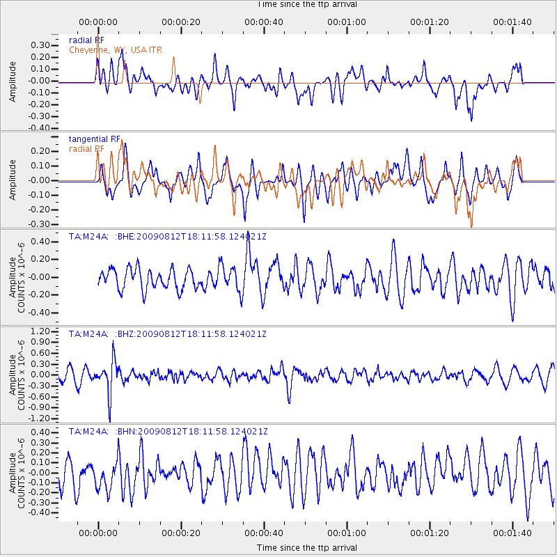
M24A Cheyenne, WY, USA - Earthquake Result Viewer
*The percent match for this event was below the threshold and hence no stack was calculated.
| Earthquake location: |
Catamarca Province, Argentina |
| Earthquake latitude/longitude: |
-27.9/-66.7 |
| Earthquake time(UTC): |
2009/08/12 (224) 18:00:52 GMT |
| Earthquake Depth: |
174 km |
| Earthquake Magnitude: |
5.5 MW, 5.3 MB, 5.5 MW |
| Earthquake Catalog/Contributor: |
WHDF/NEIC |
|
| Network: |
TA USArray Transportable Network (new EarthScope stations) |
| Station: |
M24A Cheyenne, WY, USA |
| Lat/Lon: |
41.47 N/104.82 W |
| Elevation: |
1816 m |
|
| Distance: |
77.5 deg |
| Az: |
331.608 deg |
| Baz: |
145.943 deg |
| Ray Param: |
$rayparam |
*The percent match for this event was below the threshold and hence was not used in the summary stack. |
|
| Radial Match: |
50.098217 % |
| Radial Bump: |
400 |
| Transverse Match: |
64.822685 % |
| Transverse Bump: |
396 |
| SOD ConfigId: |
2622 |
| Insert Time: |
2010-03-06 21:04:21.242 +0000 |
| GWidth: |
2.5 |
| Max Bumps: |
400 |
| Tol: |
0.001 |
|
Signal To Noise
| Channel | StoN | STA | LTA |
| TA:M24A: :BHZ:20090812T18:11:58.124021Z | 3.2670896 | 4.5348972E-7 | 1.388054E-7 |
| TA:M24A: :BHN:20090812T18:11:58.124021Z | 0.77756023 | 1.5030416E-7 | 1.9330228E-7 |
| TA:M24A: :BHE:20090812T18:11:58.124021Z | 1.3476832 | 1.4938632E-7 | 1.1084677E-7 |
| Arrivals |
| Ps | |
| PpPs | |
| PsPs/PpSs | |


