You are here: Home > Network List > TA - USArray Transportable Network (new EarthScope stations) Stations List
> Station M24A Cheyenne, WY, USA > Earthquake Result Viewer
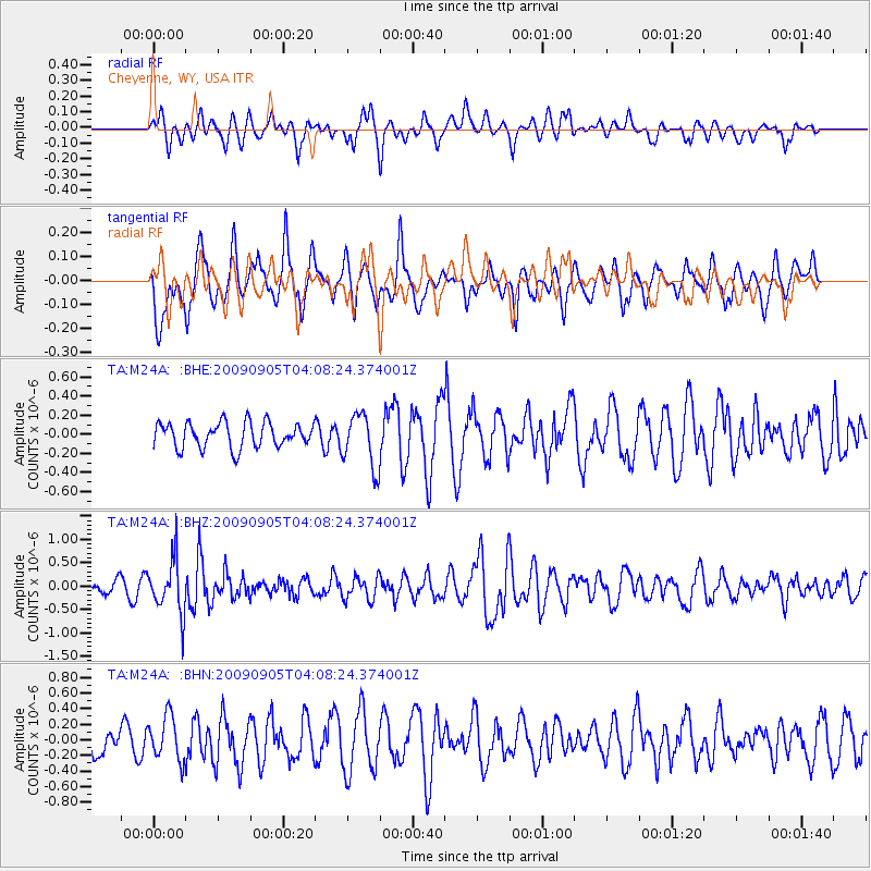
M24A Cheyenne, WY, USA - Earthquake Result Viewer
*The percent match for this event was below the threshold and hence no stack was calculated.
| Earthquake location: |
Southern Peru |
| Earthquake latitude/longitude: |
-15.1/-70.2 |
| Earthquake time(UTC): |
2009/09/05 (248) 03:58:39 GMT |
| Earthquake Depth: |
210 km |
| Earthquake Magnitude: |
5.8 MW, 5.2 MB, 5.8 MW |
| Earthquake Catalog/Contributor: |
WHDF/NEIC |
|
| Network: |
TA USArray Transportable Network (new EarthScope stations) |
| Station: |
M24A Cheyenne, WY, USA |
| Lat/Lon: |
41.47 N/104.82 W |
| Elevation: |
1816 m |
|
| Distance: |
64.7 deg |
| Az: |
331.864 deg |
| Baz: |
142.697 deg |
| Ray Param: |
$rayparam |
*The percent match for this event was below the threshold and hence was not used in the summary stack. |
|
| Radial Match: |
61.84245 % |
| Radial Bump: |
400 |
| Transverse Match: |
65.10893 % |
| Transverse Bump: |
400 |
| SOD ConfigId: |
2622 |
| Insert Time: |
2010-03-06 21:04:22.249 +0000 |
| GWidth: |
2.5 |
| Max Bumps: |
400 |
| Tol: |
0.001 |
|
Signal To Noise
| Channel | StoN | STA | LTA |
| TA:M24A: :BHZ:20090905T04:08:24.374001Z | 4.68749 | 5.682802E-7 | 1.2123337E-7 |
| TA:M24A: :BHN:20090905T04:08:24.374001Z | 1.6610126 | 2.820984E-7 | 1.6983519E-7 |
| TA:M24A: :BHE:20090905T04:08:24.374001Z | 2.1435673 | 2.814018E-7 | 1.3127735E-7 |
| Arrivals |
| Ps | |
| PpPs | |
| PsPs/PpSs | |


