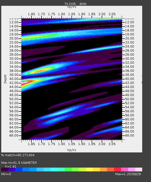
DGR Domenigoni Valley Reservior, California, USA - Earthquake Result Viewer
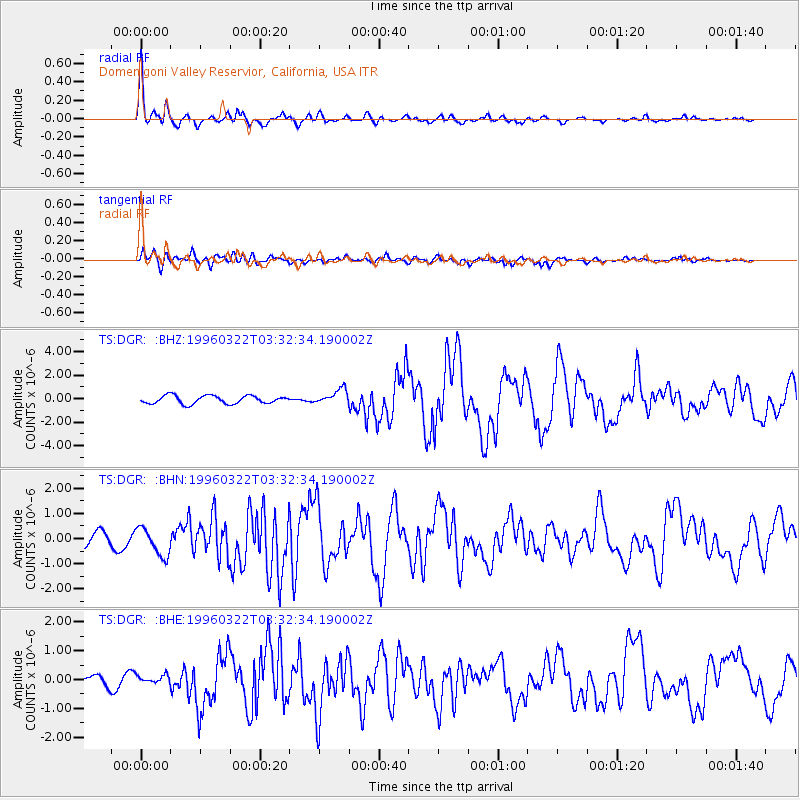
Earthquake location: Rat Islands, Aleutian Islands
Earthquake latitude/longitude: 51.2/178.7
Earthquake time(UTC): 1996/03/22 (082) 03:24:20 GMT
Earthquake Depth: 20 km
Earthquake Magnitude: 5.7 MB, 6.6 MS, 6.8 UNKNOWN, 6.6 ML
Earthquake Catalog/Contributor: WHDF/NEIC
Network: TS TERRAscope (Southern California Seismic Network)
Station: DGR Domenigoni Valley Reservior, California, USA
Lat/Lon: 33.65 N/117.01 W
Elevation: 700 m
Distance: 49.0 deg
Az: 85.015 deg
Baz: 311.318 deg
Ray Param: 0.068974525
Estimated Moho Depth: 41.5 km
Estimated Crust Vp/Vs: 1.61
Assumed Crust Vp: 6.264 km/s
Estimated Crust Vs: 3.89 km/s
Estimated Crust Poisson's Ratio: 0.19
Radial Match: 90.271484 %
Radial Bump: 322
Transverse Match: 67.62954 %
Transverse Bump: 400
SOD ConfigId: 6273
Insert Time: 2010-02-26 14:09:10.780 +0000
GWidth: 2.5
Max Bumps: 400
Tol: 0.001

Signal To Noise

ChannelStoNSTALTA
TS:DGR: :BHN:19960322T03:32:34.190002Z2.22210365.525284E-72.4865102E-7
TS:DGR: :BHE:19960322T03:32:34.190002Z0.81281951.5021321E-71.8480512E-7
TS:DGR: :BHZ:19960322T03:32:34.190002Z1.8506936.195305E-73.3475595E-7
Arrivals
Ps4.3 SECOND
PpPs16 SECOND
PsPs/PpSs21 SECOND