You are here: Home > Network List > TA - USArray Transportable Network (new EarthScope stations) Stations List
> Station M24A Cheyenne, WY, USA > Earthquake Result Viewer
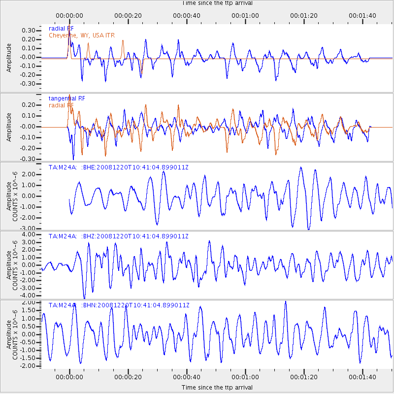
M24A Cheyenne, WY, USA - Earthquake Result Viewer
*The percent match for this event was below the threshold and hence no stack was calculated.
| Earthquake location: |
Off East Coast Of Honshu, Japan |
| Earthquake latitude/longitude: |
36.5/142.4 |
| Earthquake time(UTC): |
2008/12/20 (355) 10:29:23 GMT |
| Earthquake Depth: |
19 km |
| Earthquake Magnitude: |
6.0 MB, 6.3 MS, 6.3 MW, 6.3 MW |
| Earthquake Catalog/Contributor: |
WHDF/NEIC |
|
| Network: |
TA USArray Transportable Network (new EarthScope stations) |
| Station: |
M24A Cheyenne, WY, USA |
| Lat/Lon: |
41.47 N/104.82 W |
| Elevation: |
1816 m |
|
| Distance: |
81.0 deg |
| Az: |
44.569 deg |
| Baz: |
311.235 deg |
| Ray Param: |
$rayparam |
*The percent match for this event was below the threshold and hence was not used in the summary stack. |
|
| Radial Match: |
67.05804 % |
| Radial Bump: |
399 |
| Transverse Match: |
38.688656 % |
| Transverse Bump: |
366 |
| SOD ConfigId: |
2658 |
| Insert Time: |
2010-03-06 21:05:16.335 +0000 |
| GWidth: |
2.5 |
| Max Bumps: |
400 |
| Tol: |
0.001 |
|
Signal To Noise
| Channel | StoN | STA | LTA |
| TA:M24A: :BHZ:20081220T10:41:04.899011Z | 4.0023026 | 1.2258137E-6 | 3.0627714E-7 |
| TA:M24A: :BHN:20081220T10:41:04.899011Z | 1.9924498 | 1.2409369E-6 | 6.2281964E-7 |
| TA:M24A: :BHE:20081220T10:41:04.899011Z | 2.2286613 | 1.5805492E-6 | 7.091922E-7 |
| Arrivals |
| Ps | |
| PpPs | |
| PsPs/PpSs | |


