You are here: Home > Network List > TS - TERRAscope (Southern California Seismic Network) Stations List
> Station DGR Domenigoni Valley Reservior, California, USA > Earthquake Result Viewer
DGR Domenigoni Valley Reservior, California, USA - Earthquake Result Viewer
| Earthquake location: |
Solomon Islands |
| Earthquake latitude/longitude: |
-6.5/155.0 |
| Earthquake time(UTC): |
1996/04/29 (120) 14:40:41 GMT |
| Earthquake Depth: |
44 km |
| Earthquake Magnitude: |
6.3 MB, 7.5 MS, 7.2 UNKNOWN, 6.8 ME |
| Earthquake Catalog/Contributor: |
WHDF/NEIC |
|
| Network: |
TS TERRAscope (Southern California Seismic Network) |
| Station: |
DGR Domenigoni Valley Reservior, California, USA |
| Lat/Lon: |
33.65 N/117.01 W |
| Elevation: |
700 m |
|
| Distance: |
91.9 deg |
| Az: |
56.522 deg |
| Baz: |
263.493 deg |
| Ray Param: |
0.04152615 |
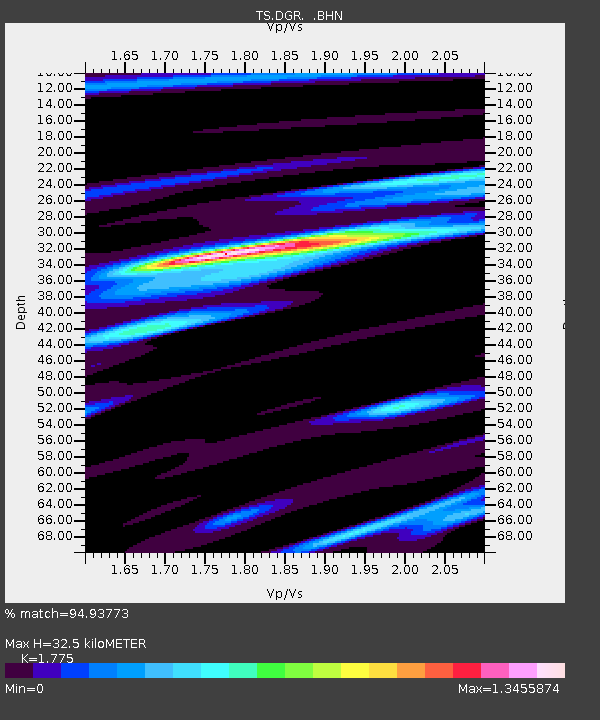
| Estimated Moho Depth: |
32.5 km |
| Estimated Crust Vp/Vs: |
1.77 |
| Assumed Crust Vp: |
6.264 km/s |
| Estimated Crust Vs: |
3.529 km/s |
| Estimated Crust Poisson's Ratio: |
0.27 |
|
| Radial Match: |
94.93773 % |
| Radial Bump: |
327 |
| Transverse Match: |
79.9798 % |
| Transverse Bump: |
400 |
| SOD ConfigId: |
6273 |
| Insert Time: |
2010-02-26 14:09:12.248 +0000 |
| GWidth: |
2.5 |
| Max Bumps: |
400 |
| Tol: |
0.001 |
|

Signal To Noise
| Channel | StoN | STA | LTA |
| TS:DGR: :BHN:19960429T14:53:13.356018Z | 1.7830242 | 2.6006296E-7 | 1.4585498E-7 |
| TS:DGR: :BHE:19960429T14:53:13.356018Z | 2.5175683 | 4.185716E-7 | 1.6626028E-7 |
| TS:DGR: :BHZ:19960429T14:53:13.356018Z | 6.9846396 | 1.5034341E-6 | 2.1524862E-7 |
| Arrivals |
| Ps | 4.1 SECOND |
| PpPs | 14 SECOND |
| PsPs/PpSs | 18 SECOND |


