You are here: Home > Network List > TA - USArray Transportable Network (new EarthScope stations) Stations List
> Station M24A Cheyenne, WY, USA > Earthquake Result Viewer
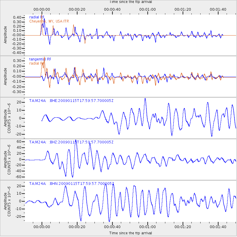
M24A Cheyenne, WY, USA - Earthquake Result Viewer
*The percent match for this event was below the threshold and hence no stack was calculated.
| Earthquake location: |
East Of Kuril Islands |
| Earthquake latitude/longitude: |
46.9/155.2 |
| Earthquake time(UTC): |
2009/01/15 (015) 17:49:39 GMT |
| Earthquake Depth: |
36 km |
| Earthquake Magnitude: |
6.9 MB, 7.5 MS, 7.4 MW, 7.4 MW |
| Earthquake Catalog/Contributor: |
WHDF/NEIC |
|
| Network: |
TA USArray Transportable Network (new EarthScope stations) |
| Station: |
M24A Cheyenne, WY, USA |
| Lat/Lon: |
41.47 N/104.82 W |
| Elevation: |
1816 m |
|
| Distance: |
67.0 deg |
| Az: |
53.489 deg |
| Baz: |
312.783 deg |
| Ray Param: |
$rayparam |
*The percent match for this event was below the threshold and hence was not used in the summary stack. |
|
| Radial Match: |
95.22458 % |
| Radial Bump: |
400 |
| Transverse Match: |
96.07521 % |
| Transverse Bump: |
374 |
| SOD ConfigId: |
2834 |
| Insert Time: |
2010-03-06 21:05:35.307 +0000 |
| GWidth: |
2.5 |
| Max Bumps: |
400 |
| Tol: |
0.001 |
|
Signal To Noise
| Channel | StoN | STA | LTA |
| TA:M24A: :BHZ:20090115T17:59:57.700005Z | 25.259842 | 1.44046935E-5 | 5.702606E-7 |
| TA:M24A: :BHN:20090115T17:59:57.700005Z | 4.5760574 | 3.7012605E-6 | 8.0883177E-7 |
| TA:M24A: :BHE:20090115T17:59:57.700005Z | 2.4620326 | 4.5537836E-6 | 1.8496032E-6 |
| Arrivals |
| Ps | |
| PpPs | |
| PsPs/PpSs | |


