You are here: Home > Network List > TA - USArray Transportable Network (new EarthScope stations) Stations List
> Station M24A Cheyenne, WY, USA > Earthquake Result Viewer
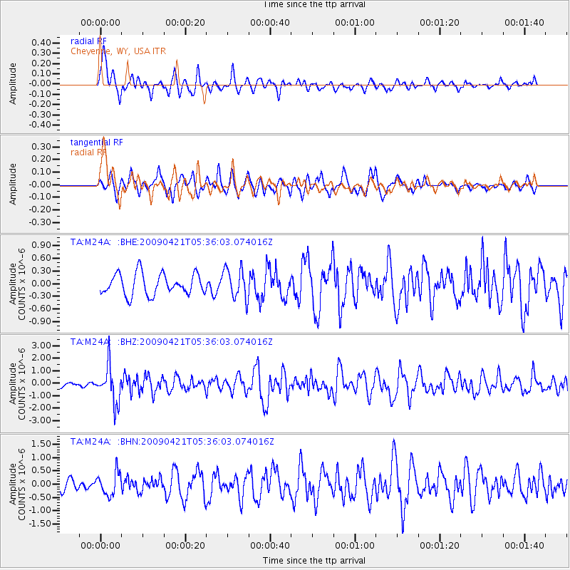
M24A Cheyenne, WY, USA - Earthquake Result Viewer
*The percent match for this event was below the threshold and hence no stack was calculated.
| Earthquake location: |
Kuril Islands |
| Earthquake latitude/longitude: |
50.8/155.0 |
| Earthquake time(UTC): |
2009/04/21 (111) 05:26:11 GMT |
| Earthquake Depth: |
152 km |
| Earthquake Magnitude: |
6.0 MB, 6.2 MW, 6.2 MW |
| Earthquake Catalog/Contributor: |
WHDF/NEIC |
|
| Network: |
TA USArray Transportable Network (new EarthScope stations) |
| Station: |
M24A Cheyenne, WY, USA |
| Lat/Lon: |
41.47 N/104.82 W |
| Elevation: |
1816 m |
|
| Distance: |
64.8 deg |
| Az: |
54.848 deg |
| Baz: |
316.378 deg |
| Ray Param: |
$rayparam |
*The percent match for this event was below the threshold and hence was not used in the summary stack. |
|
| Radial Match: |
67.86282 % |
| Radial Bump: |
400 |
| Transverse Match: |
55.12162 % |
| Transverse Bump: |
400 |
| SOD ConfigId: |
2760 |
| Insert Time: |
2010-03-06 21:05:35.984 +0000 |
| GWidth: |
2.5 |
| Max Bumps: |
400 |
| Tol: |
0.001 |
|
Signal To Noise
| Channel | StoN | STA | LTA |
| TA:M24A: :BHZ:20090421T05:36:03.074016Z | 9.4120655 | 1.499446E-6 | 1.5931104E-7 |
| TA:M24A: :BHN:20090421T05:36:03.074016Z | 1.1542655 | 4.3741628E-7 | 3.7895637E-7 |
| TA:M24A: :BHE:20090421T05:36:03.074016Z | 1.4393613 | 3.650239E-7 | 2.536013E-7 |
| Arrivals |
| Ps | |
| PpPs | |
| PsPs/PpSs | |


