You are here: Home > Network List > TA - USArray Transportable Network (new EarthScope stations) Stations List
> Station TOLK Toolik Lake Research Station, AK, USA > Earthquake Result Viewer
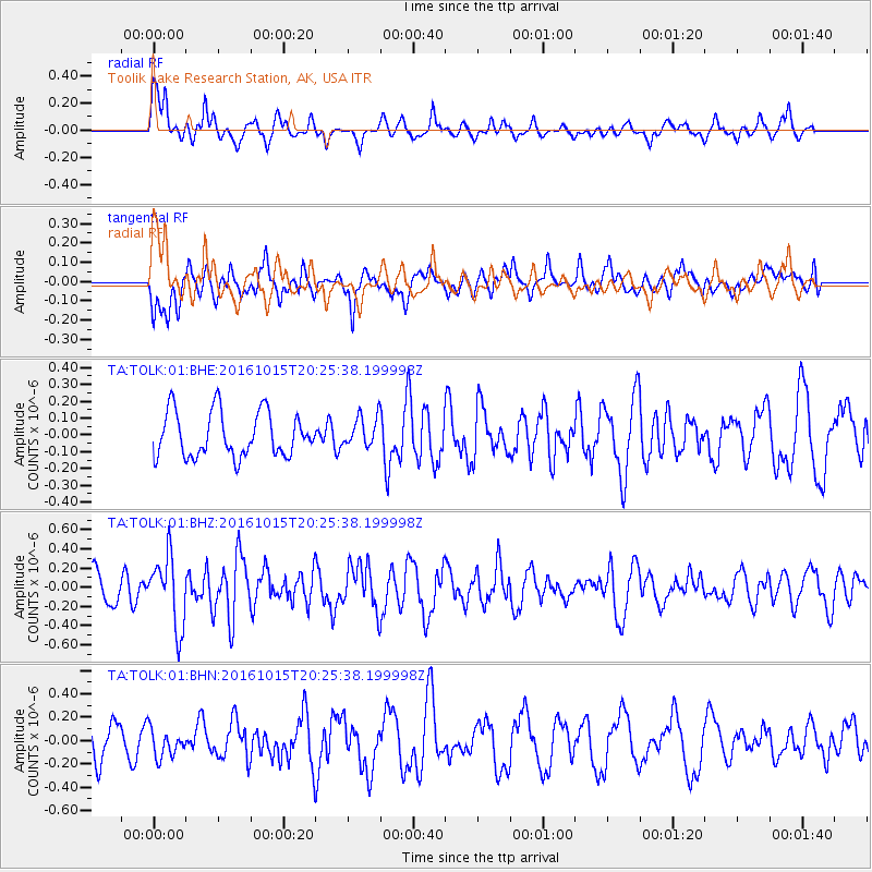
TOLK Toolik Lake Research Station, AK, USA - Earthquake Result Viewer
*The percent match for this event was below the threshold and hence no stack was calculated.
| Earthquake location: |
Greece-Albania Border Region |
| Earthquake latitude/longitude: |
39.8/20.7 |
| Earthquake time(UTC): |
2016/10/15 (289) 20:14:49 GMT |
| Earthquake Depth: |
22 km |
| Earthquake Magnitude: |
5.5 MWW, 5.3 MWB, 5.5 MWC |
| Earthquake Catalog/Contributor: |
NEIC PDE/NEIC COMCAT |
|
| Network: |
TA USArray Transportable Network (new EarthScope stations) |
| Station: |
TOLK Toolik Lake Research Station, AK, USA |
| Lat/Lon: |
68.64 N/149.57 W |
| Elevation: |
760 m |
|
| Distance: |
71.6 deg |
| Az: |
356.244 deg |
| Baz: |
7.917 deg |
| Ray Param: |
$rayparam |
*The percent match for this event was below the threshold and hence was not used in the summary stack. |
|
| Radial Match: |
64.94031 % |
| Radial Bump: |
400 |
| Transverse Match: |
53.3829 % |
| Transverse Bump: |
400 |
| SOD ConfigId: |
1634031 |
| Insert Time: |
2016-10-29 20:24:30.481 +0000 |
| GWidth: |
2.5 |
| Max Bumps: |
400 |
| Tol: |
0.001 |
|
Signal To Noise
| Channel | StoN | STA | LTA |
| TA:TOLK:01:BHZ:20161015T20:25:38.199998Z | 1.8932146 | 3.6821115E-7 | 1.9448991E-7 |
| TA:TOLK:01:BHN:20161015T20:25:38.199998Z | 0.9670208 | 1.1973293E-7 | 1.2381629E-7 |
| TA:TOLK:01:BHE:20161015T20:25:38.199998Z | 0.66620797 | 8.8388425E-8 | 1.3267393E-7 |
| Arrivals |
| Ps | |
| PpPs | |
| PsPs/PpSs | |


