You are here: Home > Network List > AU - Australian Seismological Centre Stations List
> Station XMI Christmas Island Airport > Earthquake Result Viewer
XMI Christmas Island Airport - Earthquake Result Viewer
| Earthquake location: |
New Britain Region, P.N.G. |
| Earthquake latitude/longitude: |
-5.7/151.1 |
| Earthquake time(UTC): |
2019/03/30 (089) 11:20:44 GMT |
| Earthquake Depth: |
57 km |
| Earthquake Magnitude: |
6.1 Mww |
| Earthquake Catalog/Contributor: |
NEIC PDE/us |
|
| Network: |
AU Australian Seismological Centre |
| Station: |
XMI Christmas Island Airport |
| Lat/Lon: |
10.45 S/105.69 E |
| Elevation: |
252 m |
|
| Distance: |
45.2 deg |
| Az: |
260.954 deg |
| Baz: |
87.632 deg |
| Ray Param: |
0.071286134 |
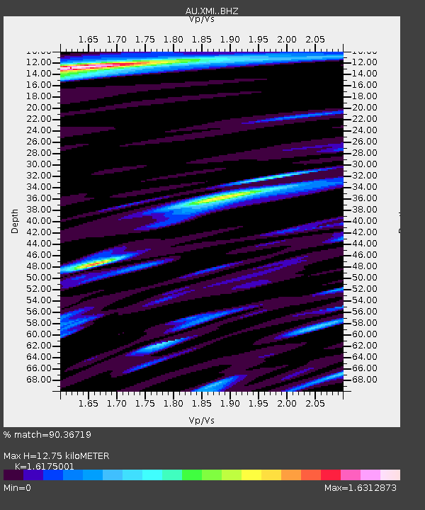
| Estimated Moho Depth: |
12.75 km |
| Estimated Crust Vp/Vs: |
1.62 |
| Assumed Crust Vp: |
4.157 km/s |
| Estimated Crust Vs: |
2.57 km/s |
| Estimated Crust Poisson's Ratio: |
0.19 |
|
| Radial Match: |
90.36719 % |
| Radial Bump: |
400 |
| Transverse Match: |
66.279884 % |
| Transverse Bump: |
400 |
| SOD ConfigId: |
13570011 |
| Insert Time: |
2019-05-02 20:15:47.592 +0000 |
| GWidth: |
2.5 |
| Max Bumps: |
400 |
| Tol: |
0.001 |
|

Signal To Noise
| Channel | StoN | STA | LTA |
| AU:XMI: :BHZ:20190330T11:28:24.918997Z | 8.610091 | 3.9865113E-6 | 4.630045E-7 |
| AU:XMI: :BHN:20190330T11:28:24.918997Z | 1.1043947 | 5.391526E-7 | 4.8818833E-7 |
| AU:XMI: :BHE:20190330T11:28:24.918997Z | 3.4588068 | 2.6708815E-6 | 7.721974E-7 |
| Arrivals |
| Ps | 1.9 SECOND |
| PpPs | 7.8 SECOND |
| PsPs/PpSs | 9.8 SECOND |


