You are here: Home > Network List > G - GEOSCOPE Stations List
> Station DRV Dumont d'Urville, Terre Adelie (Antartica) > Earthquake Result Viewer
DRV Dumont d'Urville, Terre Adelie (Antartica) - Earthquake Result Viewer
| Earthquake location: |
New Britain Region, P.N.G. |
| Earthquake latitude/longitude: |
-6.1/148.9 |
| Earthquake time(UTC): |
2016/10/17 (291) 06:14:58 GMT |
| Earthquake Depth: |
35 km |
| Earthquake Magnitude: |
6.9 MO |
| Earthquake Catalog/Contributor: |
NEIC PDE/NEIC ALERT |
|
| Network: |
G GEOSCOPE |
| Station: |
DRV Dumont d'Urville, Terre Adelie (Antartica) |
| Lat/Lon: |
66.67 S/140.01 E |
| Elevation: |
40 m |
|
| Distance: |
60.8 deg |
| Az: |
184.026 deg |
| Baz: |
10.094 deg |
| Ray Param: |
0.06121651 |
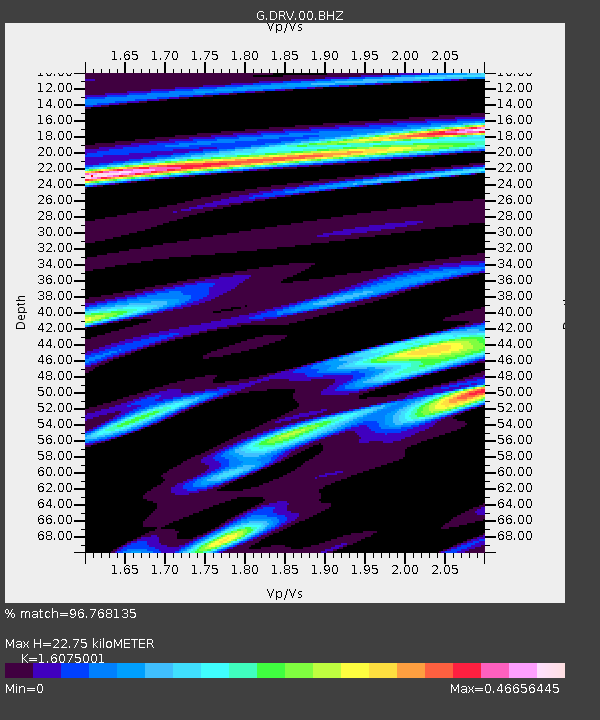
| Estimated Moho Depth: |
22.75 km |
| Estimated Crust Vp/Vs: |
1.61 |
| Assumed Crust Vp: |
6.39 km/s |
| Estimated Crust Vs: |
3.975 km/s |
| Estimated Crust Poisson's Ratio: |
0.18 |
|
| Radial Match: |
96.768135 % |
| Radial Bump: |
376 |
| Transverse Match: |
88.69494 % |
| Transverse Bump: |
400 |
| SOD ConfigId: |
1634031 |
| Insert Time: |
2016-10-31 06:16:09.954 +0000 |
| GWidth: |
2.5 |
| Max Bumps: |
400 |
| Tol: |
0.001 |
|
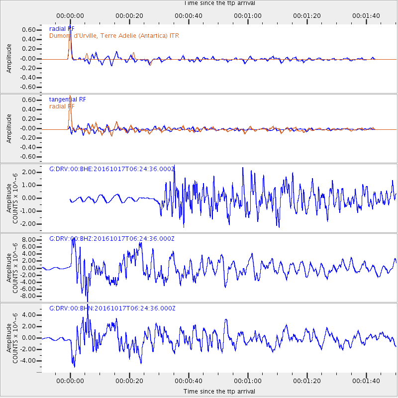
Signal To Noise
| Channel | StoN | STA | LTA |
| G:DRV:00:BHZ:20161017T06:24:36.000Z | 17.804125 | 4.5280235E-6 | 2.5432442E-7 |
| G:DRV:00:BHN:20161017T06:24:36.000Z | 11.87745 | 2.3251635E-6 | 1.9576285E-7 |
| G:DRV:00:BHE:20161017T06:24:36.000Z | 3.8341856 | 6.820342E-7 | 1.7788241E-7 |
| Arrivals |
| Ps | 2.3 SECOND |
| PpPs | 8.8 SECOND |
| PsPs/PpSs | 11 SECOND |


