You are here: Home > Network List > G - GEOSCOPE Stations List
> Station ROCAM Leguat Reserve, Rodrigues Island, Republic of Mauritius > Earthquake Result Viewer
ROCAM Leguat Reserve, Rodrigues Island, Republic of Mauritius - Earthquake Result Viewer
| Earthquake location: |
New Britain Region, P.N.G. |
| Earthquake latitude/longitude: |
-6.1/148.9 |
| Earthquake time(UTC): |
2016/10/17 (291) 06:14:58 GMT |
| Earthquake Depth: |
35 km |
| Earthquake Magnitude: |
6.9 MO |
| Earthquake Catalog/Contributor: |
NEIC PDE/NEIC ALERT |
|
| Network: |
G GEOSCOPE |
| Station: |
ROCAM Leguat Reserve, Rodrigues Island, Republic of Mauritius |
| Lat/Lon: |
19.76 S/63.37 E |
| Elevation: |
52 m |
|
| Distance: |
83.8 deg |
| Az: |
250.831 deg |
| Baz: |
94.176 deg |
| Ray Param: |
0.045916006 |
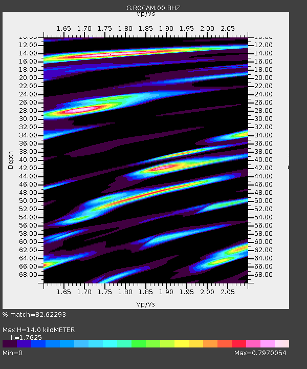
| Estimated Moho Depth: |
14.0 km |
| Estimated Crust Vp/Vs: |
1.76 |
| Assumed Crust Vp: |
4.802 km/s |
| Estimated Crust Vs: |
2.724 km/s |
| Estimated Crust Poisson's Ratio: |
0.26 |
|
| Radial Match: |
82.62293 % |
| Radial Bump: |
400 |
| Transverse Match: |
82.414825 % |
| Transverse Bump: |
400 |
| SOD ConfigId: |
1634031 |
| Insert Time: |
2016-10-31 06:16:22.605 +0000 |
| GWidth: |
2.5 |
| Max Bumps: |
400 |
| Tol: |
0.001 |
|

Signal To Noise
| Channel | StoN | STA | LTA |
| G:ROCAM:00:BHZ:20161017T06:26:52.348999Z | 7.7740297 | 1.1810807E-5 | 1.5192645E-6 |
| G:ROCAM:00:BHN:20161017T06:26:52.348999Z | 1.724373 | 1.2798412E-6 | 7.422067E-7 |
| G:ROCAM:00:BHE:20161017T06:26:52.348999Z | 2.3637054 | 3.4682387E-6 | 1.4672889E-6 |
| Arrivals |
| Ps | 2.3 SECOND |
| PpPs | 7.9 SECOND |
| PsPs/PpSs | 10 SECOND |


