You are here: Home > Network List > TA - USArray Transportable Network (new EarthScope stations) Stations List
> Station B18K Kokolik River, AK, USA > Earthquake Result Viewer
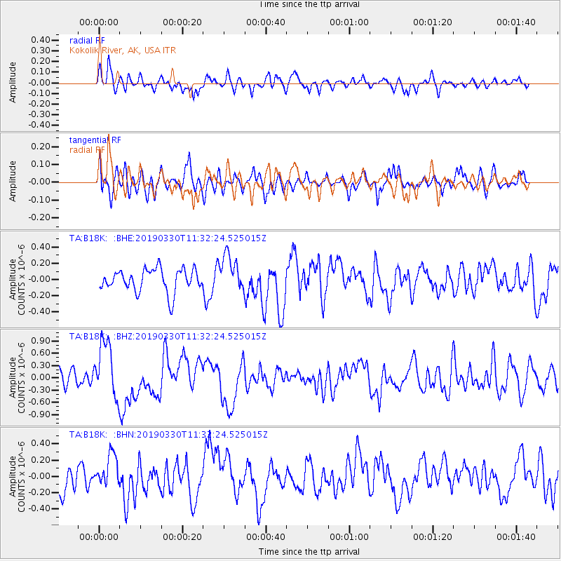
B18K Kokolik River, AK, USA - Earthquake Result Viewer
*The percent match for this event was below the threshold and hence no stack was calculated.
| Earthquake location: |
New Britain Region, P.N.G. |
| Earthquake latitude/longitude: |
-5.7/151.1 |
| Earthquake time(UTC): |
2019/03/30 (089) 11:20:44 GMT |
| Earthquake Depth: |
57 km |
| Earthquake Magnitude: |
6.1 Mww |
| Earthquake Catalog/Contributor: |
NEIC PDE/us |
|
| Network: |
TA USArray Transportable Network (new EarthScope stations) |
| Station: |
B18K Kokolik River, AK, USA |
| Lat/Lon: |
69.36 N/161.80 W |
| Elevation: |
222 m |
|
| Distance: |
81.5 deg |
| Az: |
15.226 deg |
| Baz: |
227.497 deg |
| Ray Param: |
$rayparam |
*The percent match for this event was below the threshold and hence was not used in the summary stack. |
|
| Radial Match: |
68.38026 % |
| Radial Bump: |
400 |
| Transverse Match: |
60.131313 % |
| Transverse Bump: |
400 |
| SOD ConfigId: |
13570011 |
| Insert Time: |
2019-05-02 20:20:11.016 +0000 |
| GWidth: |
2.5 |
| Max Bumps: |
400 |
| Tol: |
0.001 |
|
Signal To Noise
| Channel | StoN | STA | LTA |
| TA:B18K: :BHZ:20190330T11:32:24.525015Z | 3.72297 | 6.9364677E-7 | 1.8631545E-7 |
| TA:B18K: :BHN:20190330T11:32:24.525015Z | 1.2428573 | 2.0041487E-7 | 1.6125331E-7 |
| TA:B18K: :BHE:20190330T11:32:24.525015Z | 1.6098342 | 2.2716569E-7 | 1.4111123E-7 |
| Arrivals |
| Ps | |
| PpPs | |
| PsPs/PpSs | |


