You are here: Home > Network List > TA - USArray Transportable Network (new EarthScope stations) Stations List
> Station C16K Lisburne Hills, AK, USA > Earthquake Result Viewer
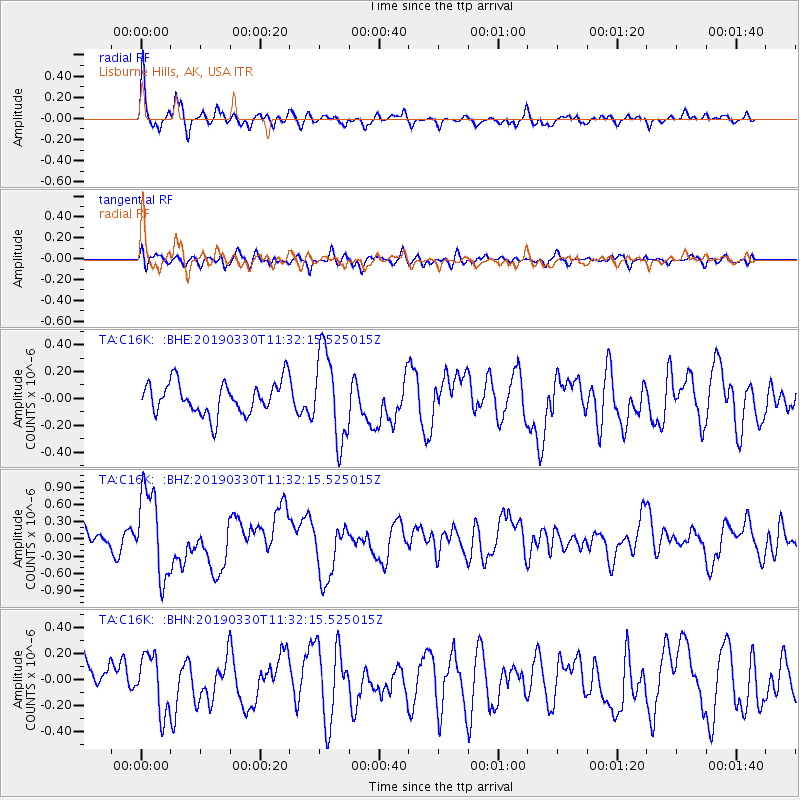
C16K Lisburne Hills, AK, USA - Earthquake Result Viewer
*The percent match for this event was below the threshold and hence no stack was calculated.
| Earthquake location: |
New Britain Region, P.N.G. |
| Earthquake latitude/longitude: |
-5.7/151.1 |
| Earthquake time(UTC): |
2019/03/30 (089) 11:20:44 GMT |
| Earthquake Depth: |
57 km |
| Earthquake Magnitude: |
6.1 Mww |
| Earthquake Catalog/Contributor: |
NEIC PDE/us |
|
| Network: |
TA USArray Transportable Network (new EarthScope stations) |
| Station: |
C16K Lisburne Hills, AK, USA |
| Lat/Lon: |
68.27 N/165.34 W |
| Elevation: |
102 m |
|
| Distance: |
79.8 deg |
| Az: |
15.113 deg |
| Baz: |
224.179 deg |
| Ray Param: |
$rayparam |
*The percent match for this event was below the threshold and hence was not used in the summary stack. |
|
| Radial Match: |
76.44463 % |
| Radial Bump: |
400 |
| Transverse Match: |
54.891964 % |
| Transverse Bump: |
400 |
| SOD ConfigId: |
13570011 |
| Insert Time: |
2019-05-02 20:20:13.890 +0000 |
| GWidth: |
2.5 |
| Max Bumps: |
400 |
| Tol: |
0.001 |
|
Signal To Noise
| Channel | StoN | STA | LTA |
| TA:C16K: :BHZ:20190330T11:32:15.525015Z | 4.3915358 | 7.4657663E-7 | 1.7000355E-7 |
| TA:C16K: :BHN:20190330T11:32:15.525015Z | 1.1552982 | 2.2023627E-7 | 1.9063154E-7 |
| TA:C16K: :BHE:20190330T11:32:15.525015Z | 2.7468839 | 3.2699737E-7 | 1.1904302E-7 |
| Arrivals |
| Ps | |
| PpPs | |
| PsPs/PpSs | |


