You are here: Home > Network List > TA - USArray Transportable Network (new EarthScope stations) Stations List
> Station E20K Nigu River, AK, USA > Earthquake Result Viewer
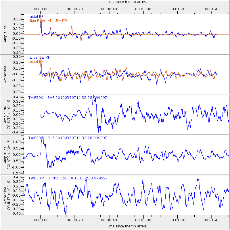
E20K Nigu River, AK, USA - Earthquake Result Viewer
*The percent match for this event was below the threshold and hence no stack was calculated.
| Earthquake location: |
New Britain Region, P.N.G. |
| Earthquake latitude/longitude: |
-5.7/151.1 |
| Earthquake time(UTC): |
2019/03/30 (089) 11:20:44 GMT |
| Earthquake Depth: |
57 km |
| Earthquake Magnitude: |
6.1 Mww |
| Earthquake Catalog/Contributor: |
NEIC PDE/us |
|
| Network: |
TA USArray Transportable Network (new EarthScope stations) |
| Station: |
E20K Nigu River, AK, USA |
| Lat/Lon: |
68.26 N/156.19 W |
| Elevation: |
866 m |
|
| Distance: |
82.3 deg |
| Az: |
17.406 deg |
| Baz: |
233.034 deg |
| Ray Param: |
$rayparam |
*The percent match for this event was below the threshold and hence was not used in the summary stack. |
|
| Radial Match: |
61.927814 % |
| Radial Bump: |
400 |
| Transverse Match: |
62.927208 % |
| Transverse Bump: |
400 |
| SOD ConfigId: |
13570011 |
| Insert Time: |
2019-05-02 20:20:25.929 +0000 |
| GWidth: |
2.5 |
| Max Bumps: |
400 |
| Tol: |
0.001 |
|
Signal To Noise
| Channel | StoN | STA | LTA |
| TA:E20K: :BHZ:20190330T11:32:28.99999Z | 6.3234067 | 7.972717E-7 | 1.2608263E-7 |
| TA:E20K: :BHN:20190330T11:32:28.99999Z | 1.4281242 | 1.729526E-7 | 1.2110473E-7 |
| TA:E20K: :BHE:20190330T11:32:28.99999Z | 4.1932154 | 2.6085092E-7 | 6.220785E-8 |
| Arrivals |
| Ps | |
| PpPs | |
| PsPs/PpSs | |


