You are here: Home > Network List > TA - USArray Transportable Network (new EarthScope stations) Stations List
> Station I27K Kandik River, AK, USA > Earthquake Result Viewer
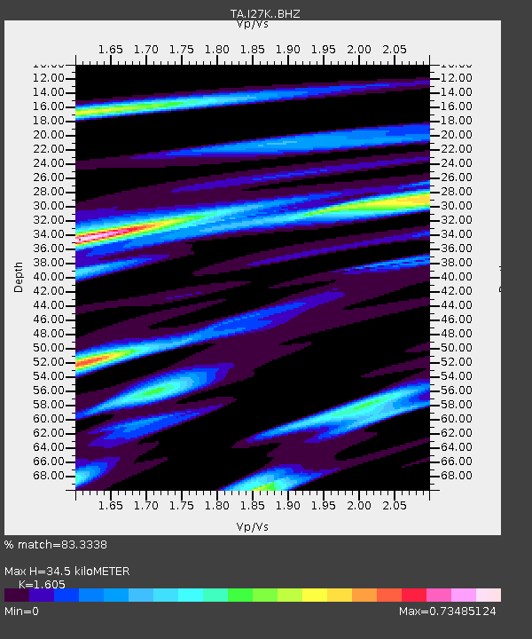
I27K Kandik River, AK, USA - Earthquake Result Viewer
| Earthquake location: |
New Britain Region, P.N.G. |
| Earthquake latitude/longitude: |
-5.7/151.1 |
| Earthquake time(UTC): |
2019/03/30 (089) 11:20:44 GMT |
| Earthquake Depth: |
57 km |
| Earthquake Magnitude: |
6.1 Mww |
| Earthquake Catalog/Contributor: |
NEIC PDE/us |
|
| Network: |
TA USArray Transportable Network (new EarthScope stations) |
| Station: |
I27K Kandik River, AK, USA |
| Lat/Lon: |
65.60 N/141.62 W |
| Elevation: |
874 m |
|
| Distance: |
86.0 deg |
| Az: |
22.589 deg |
| Baz: |
246.971 deg |
| Ray Param: |
0.044280436 |
| Estimated Moho Depth: |
34.5 km |
| Estimated Crust Vp/Vs: |
1.61 |
| Assumed Crust Vp: |
6.566 km/s |
| Estimated Crust Vs: |
4.091 km/s |
| Estimated Crust Poisson's Ratio: |
0.18 |
|
| Radial Match: |
83.3338 % |
| Radial Bump: |
400 |
| Transverse Match: |
66.82648 % |
| Transverse Bump: |
400 |
| SOD ConfigId: |
13570011 |
| Insert Time: |
2019-05-02 20:21:05.861 +0000 |
| GWidth: |
2.5 |
| Max Bumps: |
400 |
| Tol: |
0.001 |
|

Signal To Noise
| Channel | StoN | STA | LTA |
| TA:I27K: :BHZ:20190330T11:32:47.424978Z | 6.242327 | 9.3743756E-7 | 1.5017437E-7 |
| TA:I27K: :BHN:20190330T11:32:47.424978Z | 2.1824234 | 2.6308737E-7 | 1.2054826E-7 |
| TA:I27K: :BHE:20190330T11:32:47.424978Z | 3.366932 | 3.9117614E-7 | 1.1618178E-7 |
| Arrivals |
| Ps | 3.3 SECOND |
| PpPs | 13 SECOND |
| PsPs/PpSs | 17 SECOND |


