You are here: Home > Network List > IU - Global Seismograph Network (GSN - IRIS/USGS) Stations List
> Station AFI Afiamalu, Samoa > Earthquake Result Viewer
AFI Afiamalu, Samoa - Earthquake Result Viewer
| Earthquake location: |
New Britain Region, P.N.G. |
| Earthquake latitude/longitude: |
-6.1/148.9 |
| Earthquake time(UTC): |
2016/10/17 (291) 06:14:58 GMT |
| Earthquake Depth: |
35 km |
| Earthquake Magnitude: |
6.9 MO |
| Earthquake Catalog/Contributor: |
NEIC PDE/NEIC ALERT |
|
| Network: |
IU Global Seismograph Network (GSN - IRIS/USGS) |
| Station: |
AFI Afiamalu, Samoa |
| Lat/Lon: |
13.91 S/171.78 W |
| Elevation: |
706 m |
|
| Distance: |
39.5 deg |
| Az: |
104.469 deg |
| Baz: |
277.404 deg |
| Ray Param: |
0.07488197 |
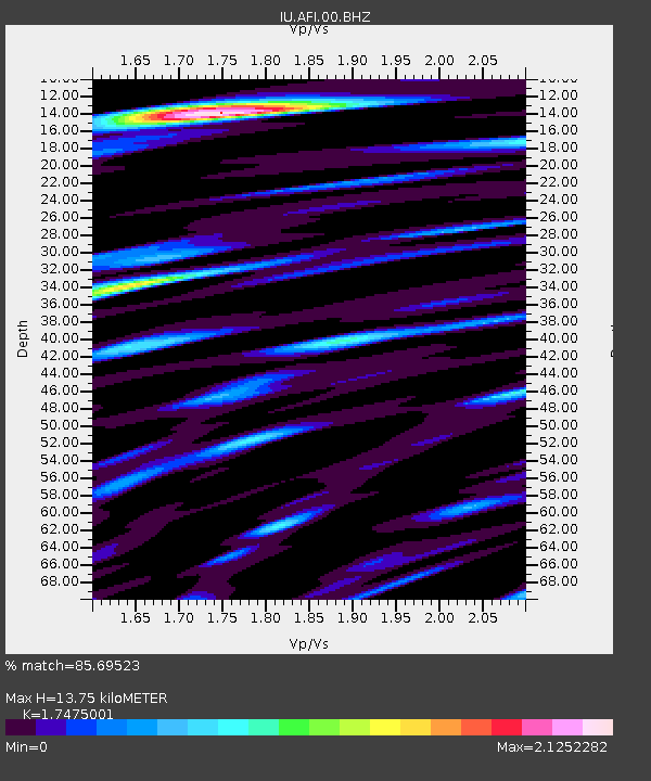
| Estimated Moho Depth: |
13.75 km |
| Estimated Crust Vp/Vs: |
1.75 |
| Assumed Crust Vp: |
4.24 km/s |
| Estimated Crust Vs: |
2.426 km/s |
| Estimated Crust Poisson's Ratio: |
0.26 |
|
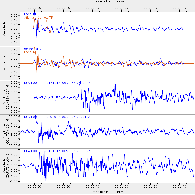
| Radial Match: |
85.69523 % |
| Radial Bump: |
400 |
| Transverse Match: |
77.34822 % |
| Transverse Bump: |
400 |
| SOD ConfigId: |
1634031 |
| Insert Time: |
2016-10-31 06:17:07.526 +0000 |
| GWidth: |
2.5 |
| Max Bumps: |
400 |
| Tol: |
0.001 |
|
Signal To Noise
| Channel | StoN | STA | LTA |
| IU:AFI:00:BHZ:20161017T06:21:54.769012Z | 11.09922 | 6.109051E-6 | 5.5040357E-7 |
| IU:AFI:00:BH1:20161017T06:21:54.769012Z | 2.575314 | 1.6897355E-6 | 6.5612795E-7 |
| IU:AFI:00:BH2:20161017T06:21:54.769012Z | 7.860002 | 4.642024E-6 | 5.905881E-7 |
| Arrivals |
| Ps | 2.5 SECOND |
| PpPs | 8.6 SECOND |
| PsPs/PpSs | 11 SECOND |


