You are here: Home > Network List > TA - USArray Transportable Network (new EarthScope stations) Stations List
> Station L15K Ungalak Mountain, AK, USA > Earthquake Result Viewer
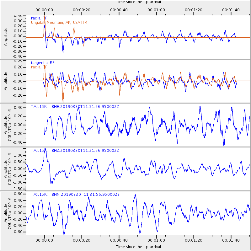
L15K Ungalak Mountain, AK, USA - Earthquake Result Viewer
*The percent match for this event was below the threshold and hence no stack was calculated.
| Earthquake location: |
New Britain Region, P.N.G. |
| Earthquake latitude/longitude: |
-5.7/151.1 |
| Earthquake time(UTC): |
2019/03/30 (089) 11:20:44 GMT |
| Earthquake Depth: |
57 km |
| Earthquake Magnitude: |
6.1 Mww |
| Earthquake Catalog/Contributor: |
NEIC PDE/us |
|
| Network: |
TA USArray Transportable Network (new EarthScope stations) |
| Station: |
L15K Ungalak Mountain, AK, USA |
| Lat/Lon: |
61.68 N/161.49 W |
| Elevation: |
219 m |
|
| Distance: |
76.4 deg |
| Az: |
21.178 deg |
| Baz: |
228.927 deg |
| Ray Param: |
$rayparam |
*The percent match for this event was below the threshold and hence was not used in the summary stack. |
|
| Radial Match: |
55.098324 % |
| Radial Bump: |
400 |
| Transverse Match: |
65.6178 % |
| Transverse Bump: |
400 |
| SOD ConfigId: |
13570011 |
| Insert Time: |
2019-05-02 20:21:20.160 +0000 |
| GWidth: |
2.5 |
| Max Bumps: |
400 |
| Tol: |
0.001 |
|
Signal To Noise
| Channel | StoN | STA | LTA |
| TA:L15K: :BHZ:20190330T11:31:56.950002Z | 5.6176524 | 9.262662E-7 | 1.6488492E-7 |
| TA:L15K: :BHN:20190330T11:31:56.950002Z | 0.9387747 | 1.6542737E-7 | 1.7621625E-7 |
| TA:L15K: :BHE:20190330T11:31:56.950002Z | 0.7982444 | 1.5033628E-7 | 1.8833363E-7 |
| Arrivals |
| Ps | |
| PpPs | |
| PsPs/PpSs | |


