You are here: Home > Network List > TA - USArray Transportable Network (new EarthScope stations) Stations List
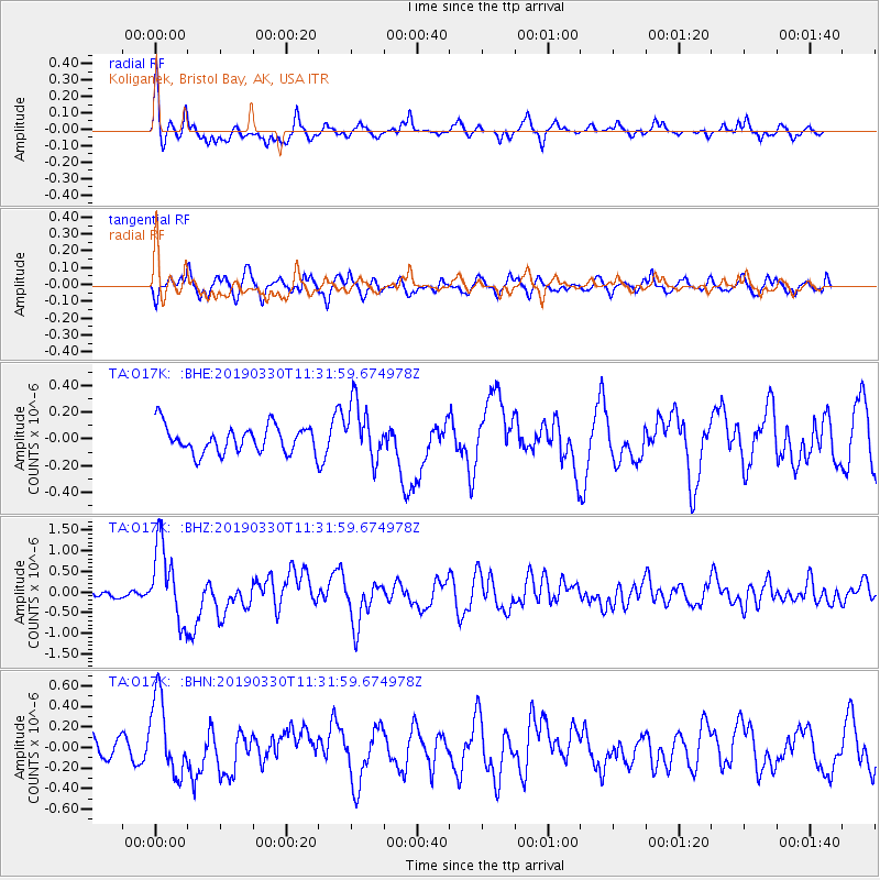
> Station O17K Koliganek, Bristol Bay, AK, USA > Earthquake Result Viewer
O17K Koliganek, Bristol Bay, AK, USA - Earthquake Result Viewer
| Earthquake location: |
New Britain Region, P.N.G. |
| Earthquake latitude/longitude: |
-5.7/151.1 |
| Earthquake time(UTC): |
2019/03/30 (089) 11:20:44 GMT |
| Earthquake Depth: |
57 km |
| Earthquake Magnitude: |
6.1 Mww |
| Earthquake Catalog/Contributor: |
NEIC PDE/us |
|
| Network: |
TA USArray Transportable Network (new EarthScope stations) |
| Station: |
O17K Koliganek, Bristol Bay, AK, USA |
| Lat/Lon: |
59.77 N/157.09 W |
| Elevation: |
156 m |
|
| Distance: |
76.9 deg |
| Az: |
24.098 deg |
| Baz: |
233.427 deg |
| Ray Param: |
0.050569583 |
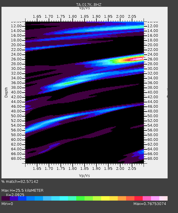
| Estimated Moho Depth: |
25.5 km |
| Estimated Crust Vp/Vs: |
2.09 |
| Assumed Crust Vp: |
6.276 km/s |
| Estimated Crust Vs: |
2.999 km/s |
| Estimated Crust Poisson's Ratio: |
0.35 |
|
| Radial Match: |
82.57142 % |
| Radial Bump: |
400 |
| Transverse Match: |
65.35853 % |
| Transverse Bump: |
372 |
| SOD ConfigId: |
13570011 |
| Insert Time: |
2019-05-02 20:21:45.641 +0000 |
| GWidth: |
2.5 |
| Max Bumps: |
400 |
| Tol: |
0.001 |
|
Signal To Noise
| Channel | StoN | STA | LTA |
| TA:O17K: :BHZ:20190330T11:31:59.674978Z | 5.895452 | 9.393135E-7 | 1.593285E-7 |
| TA:O17K: :BHN:20190330T11:31:59.674978Z | 3.015548 | 3.7365393E-7 | 1.2390913E-7 |
| TA:O17K: :BHE:20190330T11:31:59.674978Z | 2.1713414 | 2.134328E-7 | 9.8295374E-8 |
| Arrivals |
| Ps | 4.6 SECOND |
| PpPs | 12 SECOND |
| PsPs/PpSs | 17 SECOND |


