You are here: Home > Network List > TA - USArray Transportable Network (new EarthScope stations) Stations List
> Station O18K Koktuh Hills, AK, USA > Earthquake Result Viewer
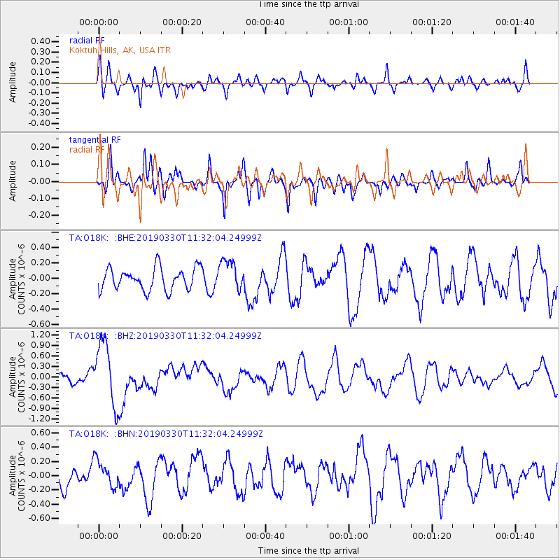
O18K Koktuh Hills, AK, USA - Earthquake Result Viewer
*The percent match for this event was below the threshold and hence no stack was calculated.
| Earthquake location: |
New Britain Region, P.N.G. |
| Earthquake latitude/longitude: |
-5.7/151.1 |
| Earthquake time(UTC): |
2019/03/30 (089) 11:20:44 GMT |
| Earthquake Depth: |
57 km |
| Earthquake Magnitude: |
6.1 Mww |
| Earthquake Catalog/Contributor: |
NEIC PDE/us |
|
| Network: |
TA USArray Transportable Network (new EarthScope stations) |
| Station: |
O18K Koktuh Hills, AK, USA |
| Lat/Lon: |
59.85 N/155.21 W |
| Elevation: |
544 m |
|
| Distance: |
77.7 deg |
| Az: |
24.601 deg |
| Baz: |
235.165 deg |
| Ray Param: |
$rayparam |
*The percent match for this event was below the threshold and hence was not used in the summary stack. |
|
| Radial Match: |
56.575684 % |
| Radial Bump: |
400 |
| Transverse Match: |
54.250988 % |
| Transverse Bump: |
400 |
| SOD ConfigId: |
13570011 |
| Insert Time: |
2019-05-02 20:21:45.879 +0000 |
| GWidth: |
2.5 |
| Max Bumps: |
400 |
| Tol: |
0.001 |
|
Signal To Noise
| Channel | StoN | STA | LTA |
| TA:O18K: :BHZ:20190330T11:32:04.24999Z | 7.6857486 | 9.396773E-7 | 1.222623E-7 |
| TA:O18K: :BHN:20190330T11:32:04.24999Z | 0.9223041 | 1.7531667E-7 | 1.9008554E-7 |
| TA:O18K: :BHE:20190330T11:32:04.24999Z | 1.4098932 | 2.0140752E-7 | 1.4285304E-7 |
| Arrivals |
| Ps | |
| PpPs | |
| PsPs/PpSs | |


