You are here: Home > Network List > TA - USArray Transportable Network (new EarthScope stations) Stations List
> Station R33M Jennings River, BC, CAN > Earthquake Result Viewer
R33M Jennings River, BC, CAN - Earthquake Result Viewer
| Earthquake location: |
New Britain Region, P.N.G. |
| Earthquake latitude/longitude: |
-5.7/151.1 |
| Earthquake time(UTC): |
2019/03/30 (089) 11:20:44 GMT |
| Earthquake Depth: |
57 km |
| Earthquake Magnitude: |
6.1 Mww |
| Earthquake Catalog/Contributor: |
NEIC PDE/us |
|
| Network: |
TA USArray Transportable Network (new EarthScope stations) |
| Station: |
R33M Jennings River, BC, CAN |
| Lat/Lon: |
59.39 N/130.97 W |
| Elevation: |
1437 m |
|
| Distance: |
88.7 deg |
| Az: |
30.032 deg |
| Baz: |
256.766 deg |
| Ray Param: |
0.042260375 |
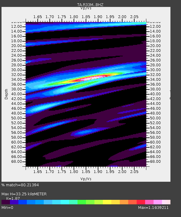
| Estimated Moho Depth: |
33.25 km |
| Estimated Crust Vp/Vs: |
1.87 |
| Assumed Crust Vp: |
6.597 km/s |
| Estimated Crust Vs: |
3.528 km/s |
| Estimated Crust Poisson's Ratio: |
0.30 |
|
| Radial Match: |
80.21394 % |
| Radial Bump: |
400 |
| Transverse Match: |
77.059906 % |
| Transverse Bump: |
400 |
| SOD ConfigId: |
13570011 |
| Insert Time: |
2019-05-02 20:22:00.759 +0000 |
| GWidth: |
2.5 |
| Max Bumps: |
400 |
| Tol: |
0.001 |
|
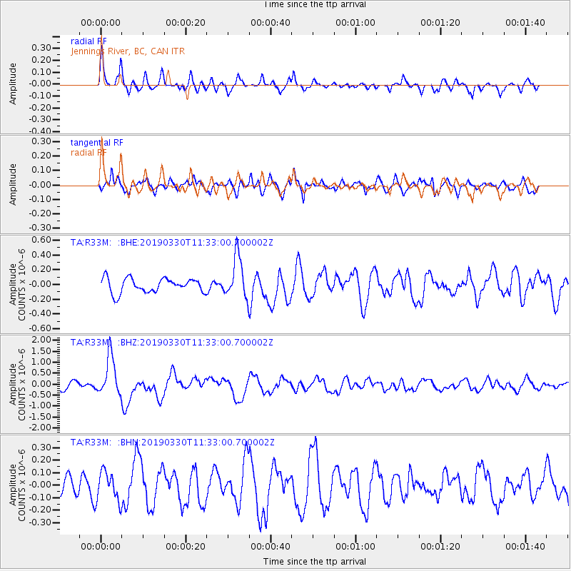
Signal To Noise
| Channel | StoN | STA | LTA |
| TA:R33M: :BHZ:20190330T11:33:00.700002Z | 6.4266214 | 9.186615E-7 | 1.4294626E-7 |
| TA:R33M: :BHN:20190330T11:33:00.700002Z | 1.2557645 | 1.1575365E-7 | 9.2177835E-8 |
| TA:R33M: :BHE:20190330T11:33:00.700002Z | 2.9354851 | 2.8259944E-7 | 9.627009E-8 |
| Arrivals |
| Ps | 4.5 SECOND |
| PpPs | 14 SECOND |
| PsPs/PpSs | 19 SECOND |


