You are here: Home > Network List > TA - USArray Transportable Network (new EarthScope stations) Stations List
> Station O25A Wiggins, CO, USA > Earthquake Result Viewer
O25A Wiggins, CO, USA - Earthquake Result Viewer
| Earthquake location: |
Kuril Islands |
| Earthquake latitude/longitude: |
51.0/157.6 |
| Earthquake time(UTC): |
2008/07/24 (206) 01:43:16 GMT |
| Earthquake Depth: |
27 km |
| Earthquake Magnitude: |
6.0 MB, 6.0 MS, 6.2 MW, 6.2 MW |
| Earthquake Catalog/Contributor: |
WHDF/NEIC |
|
| Network: |
TA USArray Transportable Network (new EarthScope stations) |
| Station: |
O25A Wiggins, CO, USA |
| Lat/Lon: |
40.11 N/104.12 W |
| Elevation: |
1444 m |
|
| Distance: |
64.7 deg |
| Az: |
57.069 deg |
| Baz: |
316.209 deg |
| Ray Param: |
0.058710553 |
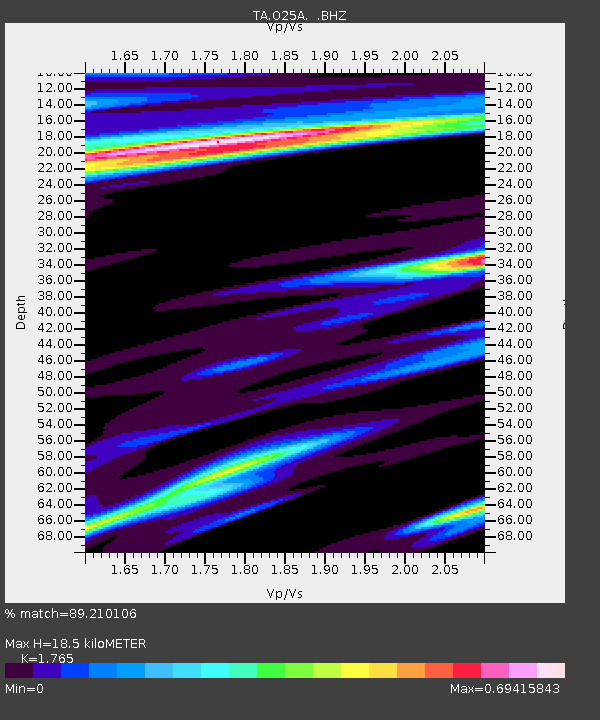
| Estimated Moho Depth: |
18.5 km |
| Estimated Crust Vp/Vs: |
1.76 |
| Assumed Crust Vp: |
6.306 km/s |
| Estimated Crust Vs: |
3.573 km/s |
| Estimated Crust Poisson's Ratio: |
0.26 |
|
| Radial Match: |
89.210106 % |
| Radial Bump: |
400 |
| Transverse Match: |
71.78381 % |
| Transverse Bump: |
400 |
| SOD ConfigId: |
2504 |
| Insert Time: |
2010-03-06 21:08:16.843 +0000 |
| GWidth: |
2.5 |
| Max Bumps: |
400 |
| Tol: |
0.001 |
|
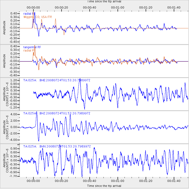
Signal To Noise
| Channel | StoN | STA | LTA |
| TA:O25A: :BHZ:20080724T01:53:20.798997Z | 15.214947 | 2.2868446E-6 | 1.5030251E-7 |
| TA:O25A: :BHN:20080724T01:53:20.798997Z | 2.7004023 | 4.980038E-7 | 1.8441838E-7 |
| TA:O25A: :BHE:20080724T01:53:20.798997Z | 4.0044765 | 6.753362E-7 | 1.6864531E-7 |
| Arrivals |
| Ps | 2.3 SECOND |
| PpPs | 7.8 SECOND |
| PsPs/PpSs | 10 SECOND |


