You are here: Home > Network List > TA - USArray Transportable Network (new EarthScope stations) Stations List
> Station O25A Wiggins, CO, USA > Earthquake Result Viewer
O25A Wiggins, CO, USA - Earthquake Result Viewer
| Earthquake location: |
Vanuatu Islands |
| Earthquake latitude/longitude: |
-13.5/167.0 |
| Earthquake time(UTC): |
2008/09/08 (252) 18:52:06 GMT |
| Earthquake Depth: |
110 km |
| Earthquake Magnitude: |
6.4 MB, 6.9 MW, 6.9 MW |
| Earthquake Catalog/Contributor: |
WHDF/NEIC |
|
| Network: |
TA USArray Transportable Network (new EarthScope stations) |
| Station: |
O25A Wiggins, CO, USA |
| Lat/Lon: |
40.11 N/104.12 W |
| Elevation: |
1444 m |
|
| Distance: |
97.7 deg |
| Az: |
50.698 deg |
| Baz: |
258.96 deg |
| Ray Param: |
0.04002922 |
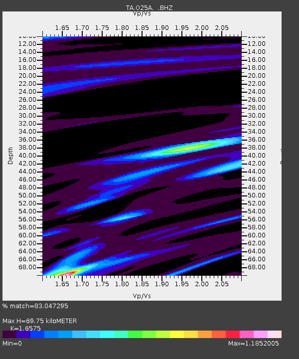
| Estimated Moho Depth: |
69.75 km |
| Estimated Crust Vp/Vs: |
1.66 |
| Assumed Crust Vp: |
6.306 km/s |
| Estimated Crust Vs: |
3.805 km/s |
| Estimated Crust Poisson's Ratio: |
0.21 |
|
| Radial Match: |
83.047295 % |
| Radial Bump: |
285 |
| Transverse Match: |
63.020653 % |
| Transverse Bump: |
315 |
| SOD ConfigId: |
2560 |
| Insert Time: |
2010-03-06 21:08:21.587 +0000 |
| GWidth: |
2.5 |
| Max Bumps: |
400 |
| Tol: |
0.001 |
|
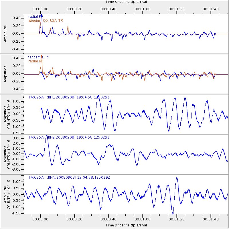
Signal To Noise
| Channel | StoN | STA | LTA |
| TA:O25A: :BHZ:20080908T19:04:58.125029Z | 7.3554263 | 1.8809355E-6 | 2.557208E-7 |
| TA:O25A: :BHN:20080908T19:04:58.125029Z | 0.7155397 | 2.0896424E-7 | 2.9203724E-7 |
| TA:O25A: :BHE:20080908T19:04:58.125029Z | 2.5895715 | 8.020226E-7 | 3.0971248E-7 |
| Arrivals |
| Ps | 7.4 SECOND |
| PpPs | 29 SECOND |
| PsPs/PpSs | 36 SECOND |


