You are here: Home > Network List > TA - USArray Transportable Network (new EarthScope stations) Stations List
> Station O25A Wiggins, CO, USA > Earthquake Result Viewer
O25A Wiggins, CO, USA - Earthquake Result Viewer
| Earthquake location: |
Central Mid-Atlantic Ridge |
| Earthquake latitude/longitude: |
8.1/-38.7 |
| Earthquake time(UTC): |
2008/09/10 (254) 13:08:14 GMT |
| Earthquake Depth: |
10 km |
| Earthquake Magnitude: |
6.3 MB, 6.5 MS, 6.6 MW, 6.6 MW |
| Earthquake Catalog/Contributor: |
WHDF/NEIC |
|
| Network: |
TA USArray Transportable Network (new EarthScope stations) |
| Station: |
O25A Wiggins, CO, USA |
| Lat/Lon: |
40.11 N/104.12 W |
| Elevation: |
1444 m |
|
| Distance: |
66.1 deg |
| Az: |
310.274 deg |
| Baz: |
99.908 deg |
| Ray Param: |
0.05786567 |
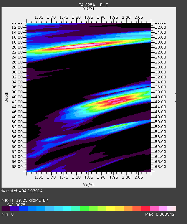
| Estimated Moho Depth: |
19.25 km |
| Estimated Crust Vp/Vs: |
1.81 |
| Assumed Crust Vp: |
6.306 km/s |
| Estimated Crust Vs: |
3.489 km/s |
| Estimated Crust Poisson's Ratio: |
0.28 |
|
| Radial Match: |
94.197914 % |
| Radial Bump: |
392 |
| Transverse Match: |
81.01636 % |
| Transverse Bump: |
400 |
| SOD ConfigId: |
2560 |
| Insert Time: |
2010-03-06 21:08:22.503 +0000 |
| GWidth: |
2.5 |
| Max Bumps: |
400 |
| Tol: |
0.001 |
|
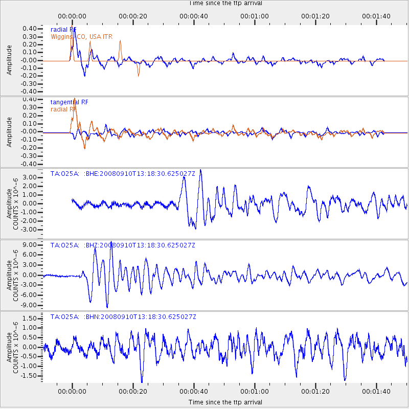
Signal To Noise
| Channel | StoN | STA | LTA |
| TA:O25A: :BHZ:20080910T13:18:30.625027Z | 2.3655827 | 4.227485E-7 | 1.7870798E-7 |
| TA:O25A: :BHN:20080910T13:18:30.625027Z | 1.2892138 | 3.0352177E-7 | 2.354317E-7 |
| TA:O25A: :BHE:20080910T13:18:30.625027Z | 1.0782359 | 2.444472E-7 | 2.267103E-7 |
| Arrivals |
| Ps | 2.6 SECOND |
| PpPs | 8.2 SECOND |
| PsPs/PpSs | 11 SECOND |


