You are here: Home > Network List > TA - USArray Transportable Network (new EarthScope stations) Stations List
> Station O25A Wiggins, CO, USA > Earthquake Result Viewer
O25A Wiggins, CO, USA - Earthquake Result Viewer
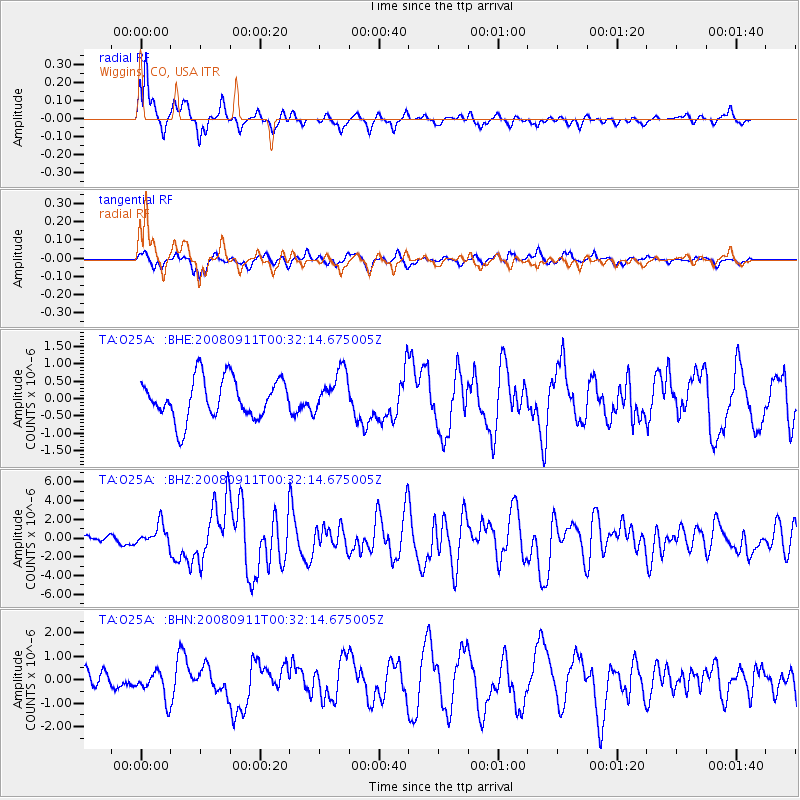
| Earthquake location: |
Hokkaido, Japan Region |
| Earthquake latitude/longitude: |
41.9/143.8 |
| Earthquake time(UTC): |
2008/09/11 (255) 00:20:50 GMT |
| Earthquake Depth: |
25 km |
| Earthquake Magnitude: |
6.1 MB, 7.0 MS, 6.8 MW, 6.8 MW |
| Earthquake Catalog/Contributor: |
WHDF/NEIC |
|
| Network: |
TA USArray Transportable Network (new EarthScope stations) |
| Station: |
O25A Wiggins, CO, USA |
| Lat/Lon: |
40.11 N/104.12 W |
| Elevation: |
1444 m |
|
| Distance: |
77.8 deg |
| Az: |
46.622 deg |
| Baz: |
314.959 deg |
| Ray Param: |
0.050044354 |
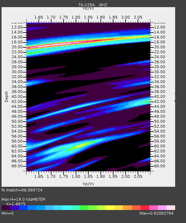
| Estimated Moho Depth: |
19.0 km |
| Estimated Crust Vp/Vs: |
1.70 |
| Assumed Crust Vp: |
6.306 km/s |
| Estimated Crust Vs: |
3.715 km/s |
| Estimated Crust Poisson's Ratio: |
0.23 |
|
| Radial Match: |
86.598724 % |
| Radial Bump: |
395 |
| Transverse Match: |
50.823006 % |
| Transverse Bump: |
341 |
| SOD ConfigId: |
2560 |
| Insert Time: |
2010-03-06 21:08:24.252 +0000 |
| GWidth: |
2.5 |
| Max Bumps: |
400 |
| Tol: |
0.001 |
|
Signal To Noise
| Channel | StoN | STA | LTA |
| TA:O25A: :BHZ:20080911T00:32:14.675005Z | 3.1713352 | 1.1080585E-6 | 3.493981E-7 |
| TA:O25A: :BHN:20080911T00:32:14.675005Z | 1.3419123 | 5.9141894E-7 | 4.4072848E-7 |
| TA:O25A: :BHE:20080911T00:32:14.675005Z | 1.031543 | 5.971451E-7 | 5.788853E-7 |
| Arrivals |
| Ps | 2.2 SECOND |
| PpPs | 7.9 SECOND |
| PsPs/PpSs | 10 SECOND |


