You are here: Home > Network List > IU - Global Seismograph Network (GSN - IRIS/USGS) Stations List
> Station POHA Pohakuloa, Hawaii, USA > Earthquake Result Viewer
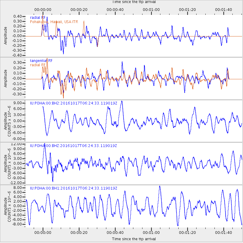
POHA Pohakuloa, Hawaii, USA - Earthquake Result Viewer
*The percent match for this event was below the threshold and hence no stack was calculated.
| Earthquake location: |
New Britain Region, P.N.G. |
| Earthquake latitude/longitude: |
-6.1/148.9 |
| Earthquake time(UTC): |
2016/10/17 (291) 06:14:58 GMT |
| Earthquake Depth: |
35 km |
| Earthquake Magnitude: |
6.9 MO |
| Earthquake Catalog/Contributor: |
NEIC PDE/NEIC ALERT |
|
| Network: |
IU Global Seismograph Network (GSN - IRIS/USGS) |
| Station: |
POHA Pohakuloa, Hawaii, USA |
| Lat/Lon: |
19.76 N/155.53 W |
| Elevation: |
1990 m |
|
| Distance: |
60.4 deg |
| Az: |
63.357 deg |
| Baz: |
250.697 deg |
| Ray Param: |
$rayparam |
*The percent match for this event was below the threshold and hence was not used in the summary stack. |
|
| Radial Match: |
64.214424 % |
| Radial Bump: |
400 |
| Transverse Match: |
42.00532 % |
| Transverse Bump: |
244 |
| SOD ConfigId: |
1634031 |
| Insert Time: |
2016-10-31 06:17:54.772 +0000 |
| GWidth: |
2.5 |
| Max Bumps: |
400 |
| Tol: |
0.001 |
|
Signal To Noise
| Channel | StoN | STA | LTA |
| IU:POHA:00:BHZ:20161017T06:24:33.119019Z | 2.4784951 | 5.593726E-6 | 2.2569043E-6 |
| IU:POHA:00:BH1:20161017T06:24:33.119019Z | 1.0210131 | 3.2280357E-6 | 3.1616005E-6 |
| IU:POHA:00:BH2:20161017T06:24:33.119019Z | 1.0267229 | 3.1143738E-6 | 3.033315E-6 |
| Arrivals |
| Ps | |
| PpPs | |
| PsPs/PpSs | |


