You are here: Home > Network List > TA - USArray Transportable Network (new EarthScope stations) Stations List
> Station O25A Wiggins, CO, USA > Earthquake Result Viewer
O25A Wiggins, CO, USA - Earthquake Result Viewer
| Earthquake location: |
Near Coast Of Venezuela |
| Earthquake latitude/longitude: |
10.7/-67.9 |
| Earthquake time(UTC): |
2009/09/12 (255) 20:06:24 GMT |
| Earthquake Depth: |
10 km |
| Earthquake Magnitude: |
6.3 MB, 6.4 MS, 6.3 MW, 6.3 MW |
| Earthquake Catalog/Contributor: |
WHDF/NEIC |
|
| Network: |
TA USArray Transportable Network (new EarthScope stations) |
| Station: |
O25A Wiggins, CO, USA |
| Lat/Lon: |
40.11 N/104.12 W |
| Elevation: |
1444 m |
|
| Distance: |
43.4 deg |
| Az: |
318.753 deg |
| Baz: |
122.335 deg |
| Ray Param: |
0.072581924 |
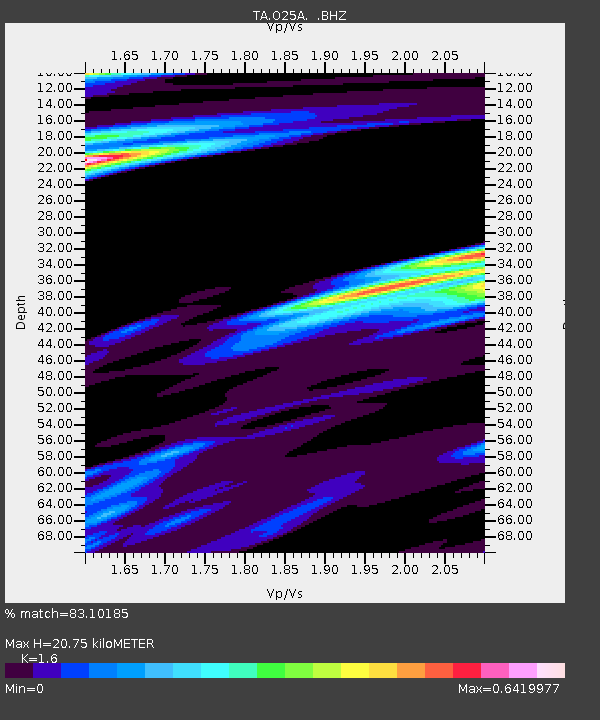
| Estimated Moho Depth: |
20.75 km |
| Estimated Crust Vp/Vs: |
1.60 |
| Assumed Crust Vp: |
6.306 km/s |
| Estimated Crust Vs: |
3.941 km/s |
| Estimated Crust Poisson's Ratio: |
0.18 |
|
| Radial Match: |
83.10185 % |
| Radial Bump: |
330 |
| Transverse Match: |
58.015762 % |
| Transverse Bump: |
309 |
| SOD ConfigId: |
2622 |
| Insert Time: |
2010-03-06 21:08:33.349 +0000 |
| GWidth: |
2.5 |
| Max Bumps: |
400 |
| Tol: |
0.001 |
|
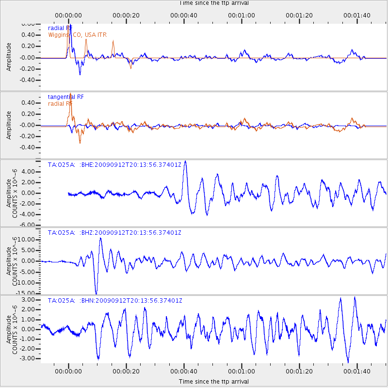
Signal To Noise
| Channel | StoN | STA | LTA |
| TA:O25A: :BHZ:20090912T20:13:56.37401Z | 4.1422224 | 9.95886E-7 | 2.404231E-7 |
| TA:O25A: :BHN:20090912T20:13:56.37401Z | 1.0681591 | 3.3241304E-7 | 3.112018E-7 |
| TA:O25A: :BHE:20090912T20:13:56.37401Z | 2.2955236 | 6.458917E-7 | 2.813701E-7 |
| Arrivals |
| Ps | 2.1 SECOND |
| PpPs | 8.0 SECOND |
| PsPs/PpSs | 10 SECOND |


