You are here: Home > Network List > TA - USArray Transportable Network (new EarthScope stations) Stations List
> Station O25A Wiggins, CO, USA > Earthquake Result Viewer
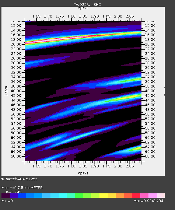
O25A Wiggins, CO, USA - Earthquake Result Viewer
| Earthquake location: |
Kermadec Islands Region |
| Earthquake latitude/longitude: |
-27.4/-176.3 |
| Earthquake time(UTC): |
2009/02/18 (049) 21:53:45 GMT |
| Earthquake Depth: |
25 km |
| Earthquake Magnitude: |
6.8 MB, 7.2 MS, 6.9 MW, 6.9 MW |
| Earthquake Catalog/Contributor: |
WHDF/NEIC |
|
| Network: |
TA USArray Transportable Network (new EarthScope stations) |
| Station: |
O25A Wiggins, CO, USA |
| Lat/Lon: |
40.11 N/104.12 W |
| Elevation: |
1444 m |
|
| Distance: |
94.9 deg |
| Az: |
47.133 deg |
| Baz: |
238.158 deg |
| Ray Param: |
0.040911112 |
| Estimated Moho Depth: |
17.5 km |
| Estimated Crust Vp/Vs: |
1.75 |
| Assumed Crust Vp: |
6.306 km/s |
| Estimated Crust Vs: |
3.614 km/s |
| Estimated Crust Poisson's Ratio: |
0.26 |
|
| Radial Match: |
84.51255 % |
| Radial Bump: |
309 |
| Transverse Match: |
69.9134 % |
| Transverse Bump: |
305 |
| SOD ConfigId: |
2658 |
| Insert Time: |
2010-03-06 21:08:38.403 +0000 |
| GWidth: |
2.5 |
| Max Bumps: |
400 |
| Tol: |
0.001 |
|

Signal To Noise
| Channel | StoN | STA | LTA |
| TA:O25A: :BHZ:20090218T22:06:33.550015Z | 5.793704 | 1.645841E-6 | 2.8407405E-7 |
| TA:O25A: :BHN:20090218T22:06:33.550015Z | 1.1404188 | 1.003736E-6 | 8.801468E-7 |
| TA:O25A: :BHE:20090218T22:06:33.550015Z | 1.2977177 | 6.416146E-7 | 4.9441763E-7 |
| Arrivals |
| Ps | 2.1 SECOND |
| PpPs | 7.5 SECOND |
| PsPs/PpSs | 9.6 SECOND |


