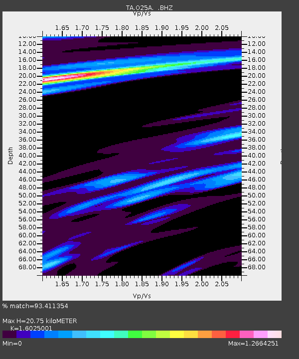
O25A Wiggins, CO, USA - Earthquake Result Viewer

Earthquake location: Rat Islands, Aleutian Islands
Earthquake latitude/longitude: 50.4/177.0
Earthquake time(UTC): 2009/07/06 (187) 14:53:12 GMT
Earthquake Depth: 22 km
Earthquake Magnitude: 6.0 MB, 5.8 MS, 6.1 MW, 6.0 MW
Earthquake Catalog/Contributor: WHDF/NEIC
Network: TA USArray Transportable Network (new EarthScope stations)
Station: O25A Wiggins, CO, USA
Lat/Lon: 40.11 N/104.12 W
Elevation: 1444 m
Distance: 54.0 deg
Az: 68.477 deg
Baz: 309.129 deg
Ray Param: 0.065698124
Estimated Moho Depth: 20.75 km
Estimated Crust Vp/Vs: 1.60
Assumed Crust Vp: 6.306 km/s
Estimated Crust Vs: 3.935 km/s
Estimated Crust Poisson's Ratio: 0.18
Radial Match: 93.411354 %
Radial Bump: 400
Transverse Match: 75.11454 %
Transverse Bump: 400
SOD ConfigId: 2648
Insert Time: 2010-03-06 21:08:50.812 +0000
GWidth: 2.5
Max Bumps: 400
Tol: 0.001

Signal To Noise

ChannelStoNSTALTA
TA:O25A: :BHZ:20090706T15:02:03.575022Z25.404933.5694543E-61.4050242E-7
TA:O25A: :BHN:20090706T15:02:03.575022Z3.49911386.608324E-71.8885709E-7
TA:O25A: :BHE:20090706T15:02:03.575022Z3.69226317.5462043E-72.0437884E-7
Arrivals
Ps2.1 SECOND
PpPs8.1 SECOND
PsPs/PpSs10 SECOND