You are here: Home > Network List > IW - Intermountain West Stations List
> Station PLID Pearl Lake, Idaho, USA > Earthquake Result Viewer
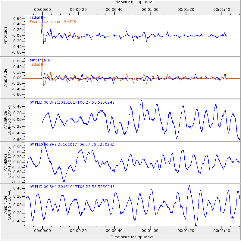
PLID Pearl Lake, Idaho, USA - Earthquake Result Viewer
*The percent match for this event was below the threshold and hence no stack was calculated.
| Earthquake location: |
New Britain Region, P.N.G. |
| Earthquake latitude/longitude: |
-6.1/148.9 |
| Earthquake time(UTC): |
2016/10/17 (291) 06:14:58 GMT |
| Earthquake Depth: |
35 km |
| Earthquake Magnitude: |
6.9 MO |
| Earthquake Catalog/Contributor: |
NEIC PDE/NEIC ALERT |
|
| Network: |
IW Intermountain West |
| Station: |
PLID Pearl Lake, Idaho, USA |
| Lat/Lon: |
45.09 N/116.00 W |
| Elevation: |
2164 m |
|
| Distance: |
97.9 deg |
| Az: |
45.42 deg |
| Baz: |
269.344 deg |
| Ray Param: |
$rayparam |
*The percent match for this event was below the threshold and hence was not used in the summary stack. |
|
| Radial Match: |
77.62908 % |
| Radial Bump: |
400 |
| Transverse Match: |
65.03039 % |
| Transverse Bump: |
349 |
| SOD ConfigId: |
1634031 |
| Insert Time: |
2016-10-31 06:18:30.420 +0000 |
| GWidth: |
2.5 |
| Max Bumps: |
400 |
| Tol: |
0.001 |
|
Signal To Noise
| Channel | StoN | STA | LTA |
| IW:PLID:00:BHZ:20161017T06:27:58.525024Z | 2.6778095 | 7.6679817E-7 | 2.8635276E-7 |
| IW:PLID:00:BH1:20161017T06:27:58.525024Z | 1.0255569 | 1.8844428E-7 | 1.8374823E-7 |
| IW:PLID:00:BH2:20161017T06:27:58.525024Z | 1.9907229 | 2.1115873E-7 | 1.0607139E-7 |
| Arrivals |
| Ps | |
| PpPs | |
| PsPs/PpSs | |


