You are here: Home > Network List > TA - USArray Transportable Network (new EarthScope stations) Stations List
> Station O25A Wiggins, CO, USA > Earthquake Result Viewer
O25A Wiggins, CO, USA - Earthquake Result Viewer
| Earthquake location: |
Off Coast Of Ecuador |
| Earthquake latitude/longitude: |
1.4/-85.2 |
| Earthquake time(UTC): |
2009/05/10 (130) 01:16:06 GMT |
| Earthquake Depth: |
6.0 km |
| Earthquake Magnitude: |
5.5 MB, 5.7 MS, 6.1 MW, 6.1 MW |
| Earthquake Catalog/Contributor: |
WHDF/NEIC |
|
| Network: |
TA USArray Transportable Network (new EarthScope stations) |
| Station: |
O25A Wiggins, CO, USA |
| Lat/Lon: |
40.11 N/104.12 W |
| Elevation: |
1444 m |
|
| Distance: |
42.2 deg |
| Az: |
338.243 deg |
| Baz: |
151.106 deg |
| Ray Param: |
0.073312186 |
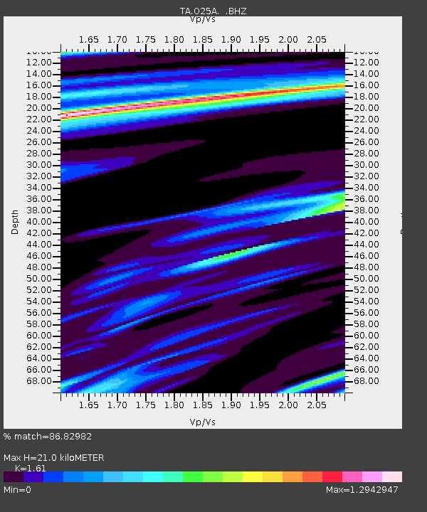
| Estimated Moho Depth: |
21.0 km |
| Estimated Crust Vp/Vs: |
1.61 |
| Assumed Crust Vp: |
6.306 km/s |
| Estimated Crust Vs: |
3.917 km/s |
| Estimated Crust Poisson's Ratio: |
0.19 |
|
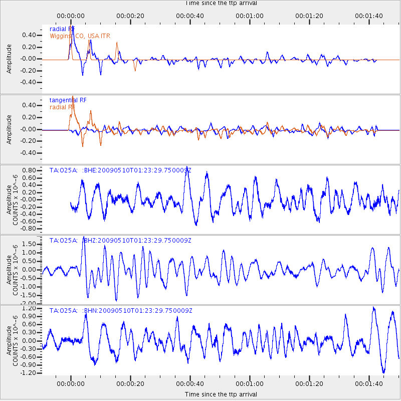
| Radial Match: |
86.82982 % |
| Radial Bump: |
341 |
| Transverse Match: |
55.20893 % |
| Transverse Bump: |
400 |
| SOD ConfigId: |
2760 |
| Insert Time: |
2010-03-06 21:08:56.597 +0000 |
| GWidth: |
2.5 |
| Max Bumps: |
400 |
| Tol: |
0.001 |
|
Signal To Noise
| Channel | StoN | STA | LTA |
| TA:O25A: :BHZ:20090510T01:23:29.750009Z | 6.004023 | 7.595332E-7 | 1.2650405E-7 |
| TA:O25A: :BHN:20090510T01:23:29.750009Z | 1.1398814 | 2.5480657E-7 | 2.2353778E-7 |
| TA:O25A: :BHE:20090510T01:23:29.750009Z | 0.5850044 | 1.4842223E-7 | 2.5371133E-7 |
| Arrivals |
| Ps | 2.2 SECOND |
| PpPs | 8.1 SECOND |
| PsPs/PpSs | 10 SECOND |


