You are here: Home > Network List > TA - USArray Transportable Network (new EarthScope stations) Stations List
> Station O25A Wiggins, CO, USA > Earthquake Result Viewer
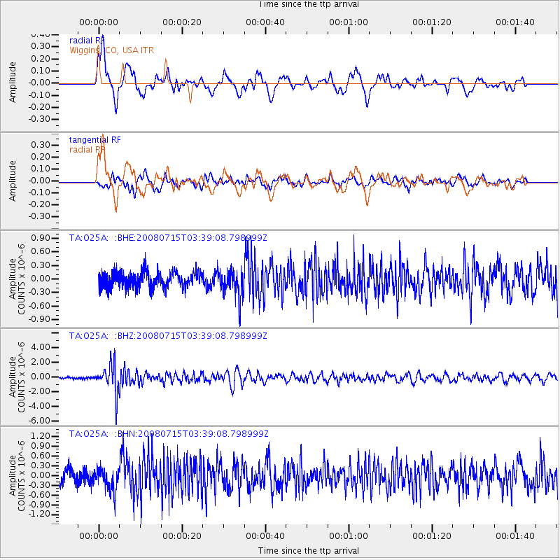
O25A Wiggins, CO, USA - Earthquake Result Viewer
*The percent match for this event was below the threshold and hence no stack was calculated.
| Earthquake location: |
Dodecanese Islands, Greece |
| Earthquake latitude/longitude: |
35.8/27.9 |
| Earthquake time(UTC): |
2008/07/15 (197) 03:26:34 GMT |
| Earthquake Depth: |
52 km |
| Earthquake Magnitude: |
6.5 MB, 6.4 MW, 6.4 MW |
| Earthquake Catalog/Contributor: |
WHDF/NEIC |
|
| Network: |
TA USArray Transportable Network (new EarthScope stations) |
| Station: |
O25A Wiggins, CO, USA |
| Lat/Lon: |
40.11 N/104.12 W |
| Elevation: |
1444 m |
|
| Distance: |
92.5 deg |
| Az: |
325.206 deg |
| Baz: |
37.22 deg |
| Ray Param: |
$rayparam |
*The percent match for this event was below the threshold and hence was not used in the summary stack. |
|
| Radial Match: |
77.68193 % |
| Radial Bump: |
400 |
| Transverse Match: |
67.776085 % |
| Transverse Bump: |
400 |
| SOD ConfigId: |
2504 |
| Insert Time: |
2010-03-06 21:08:59.949 +0000 |
| GWidth: |
2.5 |
| Max Bumps: |
400 |
| Tol: |
0.001 |
|
Signal To Noise
| Channel | StoN | STA | LTA |
| TA:O25A: :BHZ:20080715T03:39:08.798999Z | 17.136564 | 1.8675098E-6 | 1.0897807E-7 |
| TA:O25A: :BHN:20080715T03:39:08.798999Z | 2.0047321 | 3.6002453E-7 | 1.7958736E-7 |
| TA:O25A: :BHE:20080715T03:39:08.798999Z | 1.7565424 | 3.0253702E-7 | 1.722344E-7 |
| Arrivals |
| Ps | |
| PpPs | |
| PsPs/PpSs | |


